Garnberg (Künzelsau)
|
Garnberg
District town of Künzelsau
Coordinates: 49 ° 17 ′ 8 ″ N , 9 ° 42 ′ 15 ″ E
|
|
|---|---|
| Height : | 404 m |
| Residents : | 812 (December 31, 2011) |
| Incorporation : | 1912 |
|
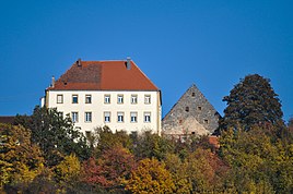
Stetten'sches Schlösschen, seen from Künzelsau (2012)
|
|
Garnberg is a district of the Baden-Württemberg district town of Künzelsau in the Hohenlohe district .
location
Garnberg stretches on the right, upper edge of the slope opposite the old town of Künzelsau, about a kilometer kocher upwards, the lowest standing buildings are at least 150 meters above the river. A district road (K 2300) opens up the place in a western loop from Langenburger Strasse from Künzelsau to Amrichshausen (L 1033).
history
Garnberg, formerly called Gagernberg or Gairenberg, was first mentioned in a deed of donation in 1090: Mechtild von Stein donated the estate to the Komburg monastery.
From 1508 to 1709 at the latest, the settlement was in the hands of Stats . Around 1688, Wolfgang Christoph von Stetten built the castle. For a long time Garnberg consisted only of the castle estate, a few farms, mercenary houses and a brickworks. It was not until the late 18th century that Georg Ferdinand Forstner von Dambenoy enlarged the place by clearing and promoting new settlements. Forstner was a professor of agriculture in Tübingen. Its aim was to increase agricultural yields.
There was a chapel near the castle. This was later converted into a barn. Your bell is now on the roof of the old Garnberg school. In 1806 Garnberg, which was in the Franconian knight circle , came under Württemberg state sovereignty and was incorporated into Künzelsau in 1912.
Garnberg was the location of a brickworks until 1985, and the Garnberger brickworks was mentioned in a document as early as 1676. The old clay pit is now a geotope .
literature
- Garnberg in the description of the Oberamt Künzelsau from 1883 ( Wikisource )
Web links
- Garnberg on the Künzelsau website
Individual evidence
- ^ Garnberg in the description of the Oberamt Künzelsau from 1883 ( Wikisource )
- ^ LEO-BW Garnberg - Baden-Württemberg State Archives. Retrieved June 16, 2012.
- ^ Brickworks Gebr. Löhlein GmbH & Co - Economic Archive Baden-Württemberg. Retrieved May 17, 2012.
- ↑ Geotope description clay pit in the east of Garnberg (PDF).

