
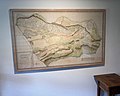
Geometric plan of the whole municipal railway of Wollishofen

Geometric plan of the entire communal railway of Wollishofen is the name of a local map from 1788. The west-facing plan shows the area of the former commune of Wollishofen , since 1893 a district of the city of Zurich . It is stored under the signature PLAN Q 349 in the Zurich State Archives.
description


The plan was drawn in ink and watercolor on a scale of 1: 2330 by the cartographer and engineer Johannes Feer (1763–1823). The original drawing measures 148.5 × 94.0 centimeters; a copy of this is exhibited in the Wollishofen local museum. The client was Amtmann Wirz from the office in the Kappelerhof in Zurich. Johann Friedrich Meiss made a copy of it in 1789 (PLAN Q 350).
in the local museum

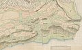
Copy by Hans Meiss, 1789

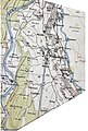
Copy by Leonhard Ziegler, 1795
Wild card , around 80 years later


General
Such plans were made in some parishes in the second half of the 18th century. They served the authorities as a planning basis for building projects of all kinds, boundary lines, tax purposes and other things.
The area shown extends in the south (left) from the Horn on the border with Kilchberg to the southwest to the Sihl and to the right in the north approximately from the «Landiwiese» to Allmend Brunau. on the Sihl, which completes the plan to the west.
The three village centers Oberdorf, Unterdorf and Rain as well as the surrounding hamlets such as Horn, Erdbrust, Am Bach, Haumesser, Mutschellen or Asp are shown. Buildings, meadows, fields and vineyards are shown.
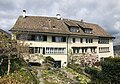
The photograph from around 1925 shows the “Rain” part of the former village. View into Tannenrauchstrasse over Albisstrasse into Alte Landstrasse. On the left the houses of the lower village. The half-timbered house at the intersection still stands today (without an extension) as one of the few witnesses of the old Wollishofen (Albisgrund House, Albisstrasse 61).
The great importance of viticulture can be seen, the area under vines was over 27 hectares. There were also 74 hectares of arable land and 8 hectares of gardens. The dry and wet meadows have hardly been fertilized. In the moss against Adliswil , peat was cut and sedge was harvested, the Allmend was mainly used as pasture for cattle.
Districts of the old Wollishofen
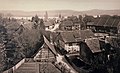
The «Rain» part of the village around 1925

House to Albisgrund
Farmhouses ...

... in the earth breast


Streets

At that time, two main streets led through Wollishofen, which separated in the Enge district at what is now the Brunaustrasse tram station. The upper one led over the Kappeli- and Bellariastrasse over the today's Mutschellenstrasse to the Morgental, then up to the Unter- and Oberdorf and along the Kalchbühlstrasse and Nidelbadstrasse to the ridge on which the settlement Neubühl is today . Then it led down to Adliswil and on over the Albis Pass towards Zug . The large marsh area of Moos, which used to stretch from the tram depot in the south of the terminus to the Grüt, was bypassed. Albisstrasse was not completed until 1845.
The lower main street led through the Haumesser to the group of houses "Am Bach", where the post office is today. There it led through the Kilchbergsteig steeply left up to the old church and then further south along today's Kilchbergstrasse. At that time, a stream flowed through the Morgental valley, which meandered down from the moss through Ober- and Unterdorf to the lake, into which it flowed at the former brickworks. There was only a narrow path, the pilgrimage route, that led directly along the lake shore. The Seestrasse was built in 1834.

The path into the Sihltal led over the «Butzen» through the «Brugghölzli» over a narrow, covered wooden bridge to the hamlet of Unter- Leimbach , the course can still be seen around 1860 on Johannes Wild's map . From 1819 you drove further down the Sihl over the Höcklerbrücke to Leimbach, until the Maneggbrücke was built there in 1892.
In addition to Butzenstrasse and the beginning of Kilchbergstrasse, Widmerstrasse formed a second east-west connection. It led from the pilgrim path by the lake up to the hamlet of Erdbrust, crossed Kalchbühlstrasse and the creek at Albisstrasse and led up to "Paradys" at the edge of the forest - today the Paradiesstrasse (all street names are today's names). The Erdbrustweg, at that time the direct connection between the upper village and the Erdbrust group of houses, which today leads from the Lee school building to the Egg, already existed back then.
The peculiar name "earth breast" means something like "earth break, mainly on a hill"; a fitting name for the settlement above a steep slope
Field names

Numerous field names are entered on the map. Some of them have survived to this day as street names such as Bey der Stud (Studackerstrasse), Im Tannenrauch (Tannenrauchstrasse), Im Rum Pump (Rumpumpsteig), Beym Erli Gatter (Erligatterweg), Im Erdbrust (Erdbrustweg), Im Paradys (Paradiesstrasse) , In der Zwängi , (Zwängiweg), Im Buzen (Butzenstrasse) or Das Tangelhölzi (Dangelstrasse). Other names like Steinbühl , Auf der Laimgrueb , Im Krieg or Kalklaaren have disappeared. The animal names include a Gaiss-Aker , Hirschstaffleten , the Küegass-Aeker , the Wolfacker , the Kazen - and the Stieren-Weyd . The term " Reyh ", which appears often, was then a spelling for "Rain"; it is still called "Rei" in the original Zurich German.
What is striking in this context is the « Galgenreyh » between lots 13 and 14, today at the car park south of the Auf der Egg church . The gallows stood in a prominent position on the crest of the moraine hill «Egg» within sight of the upper village. Probably already in the times of the Alemanni justice was pronounced in place of the old church; The judgment was then carried out on the Egg. An indication of this is a linden tree still standing there today , which was often planted in places where the court met.
literature
- Emil Stauber: Alt Wollishofen , Orell Füssli, Zurich 1926
- Rudolf Meier, Fred Winkler: Wollishofen - then and now . Niggli AG, Sulgen 1993, ISBN 3-72120-275-9