Georgenberg (Reutlingen)
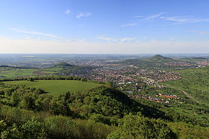
The Georgenberg ( 601.7 m above sea level ) is a conical mountain of volcanic origin in the middle of the German state of Baden-Württemberg . In the south of the city of Reutlingen it forms the boundary with the west of the smaller neighboring town of Pfullingen , with the summit and largest part of the mountain in the Pfullingen area.
In addition to the mountain itself, a district or residential area of the core city district of Reutlingen-Mitte on the northern flank of the mountain also bears the name Georgenberg .
Geology and history of the mountain

In contrast to the similarly shaped Achalm , a witness mountain from White Jura, 105 m higher, around 2.5 km northeast, the Georgenberg is of volcanic origin and has an almost symmetrical volcanic shape. It offers a panoramic view from the northern Albtrauf over the cities of Pfullingen and Reutlingen to Tübingen and (with good visibility) to the northern Black Forest .
The mountain represents one of the around 350 chimneys of the so-called Swabian volcano , which have been prepared by reversing relief , which are scattered within a radius of around 25 km around today's Bad Urach . While the chimney contains comparatively hard rock, the pierced layers of the Jura are more exposed to erosion, so that the chimney protrudes above the surroundings and emerges at the summit. At the time when this volcano in the Miocene (geological unit; time particularly active tectonics before about 17 million years ago), the volcano penetrated the then northward protruding beyond him Jura plateau . White Jurassic limes characteristic of the uppermost layer of the Jurassic plateau are occupied in the chimney. As in the chimneys of other Swabian volcanoes, which are now solitary north of the Albtraufs, the white Jurassic limes are marks for the fact that the Jurassic plateau was extended further north. The Georgenberg is also protected as a geotope under the name Vulkanschlot Georgenberg S von Reutlingen .
The mountain gets its current name from a St. George's Chapel , which was once on its summit. This little church was first mentioned in a document in 1489. The name Georgenberg has been common since 1719. Before that the elevation was called Echitzenberg or Echetzenberg.
The slopes of the Georgenberg were originally used by Reutlingers and Pfullingers to grow wine, which is why terraced landscape structures can still be seen below the summit. In 1749 the so-called "Weinberg-War" broke out between Reutlingen and Pfullingen winegrowers, which could only be settled with the use of Württemberg troops.
Individual evidence
- ↑ Map services of the Federal Agency for Nature Conservation ( information )
- ^ Geotope profile of the LGRB
Web links
Coordinates: 48 ° 28 ′ 17 ″ N , 9 ° 12 ′ 42 ″ E
