Gilberg
| Gilberg | ||
|---|---|---|
|
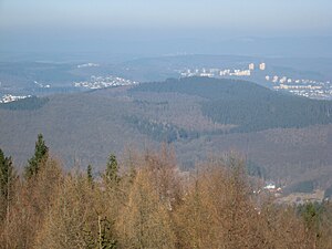
The Gilberg seen from the Pfannenberg Tower. |
||
| height | 425.9 m above sea level NHN | |
| location | North Rhine-Westphalia , Germany | |
| Mountains | Rothaar Mountains , Siegerland | |
| Coordinates | 50 ° 50 '40 " N , 7 ° 59' 59" E | |
|
|
||
| particularities | Gilbergturm ( AT ) | |
The Gilberg (also called Gilbergskopf ) is 425.9 m above sea level. NHN high mountain in the urban area of Siegen in the North Rhine-Westphalian district of Siegen-Wittgenstein .
Location and observation tower
The mountain is located above the Eiserfeld district of Siegen and southwest of the Hengsbach settlement that belongs to Eiserfeld . A section of the A 45 runs along the south-west slope of the Gilberg, and a section of the B 62 to the north-west . South of the mountain, separated by the motorway, lies the 402.4 m high Gilberg foothills, Hengsberg .
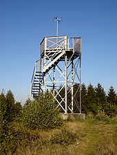
At the summit there is a 5.65 m high observation tower . The steel lattice tower was built in 1888 on behalf of the Eiserfeld Home and Improvement Association . From here you had a view of Eiserfeld, Niederschelden and Siegen in 2005 ( view from the tower ) . As of 2016, the view is very limited due to the tall trees.
Mining
The Gilberg is riddled with many tunnels , which for example belong to the Grube Gilberg , Flussberg , Talsbach , Malsch , Obere and Untere Anna and others. Many traces of the former mining, such as heaps and pings, are still visible above ground . In 1583 the St. Paul mine on Gilberg is mentioned, which was in a "rich" copper ore mining.
literature
- Hans Dietrich Gleichmann: Between “Alter Flußberg” and “Thalsbach” - Numerous old pits mined on Gilberg , in: Eiserfeld in the green crown of the mountains . In: Horst G. Koch (Hrsg.): Eiserfeld in the green wreath of the mountains. Verlag Koch, Siegen 1992.
Web links
Individual evidence
- ↑ a b Map services of the Federal Agency for Nature Conservation ( information )
- ↑ Tower height according to the sign on the tower


