Gipsberg (Ronnenberg)
| Gipsberg | ||
|---|---|---|
|
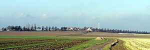
The Gipsberg seen from the south |
||
| height | 90 m above sea level NHN | |
| location | Ronnenberg , Germany | |
| Dominance | 1.3 km → Bettenser Berg | |
| Notch height | 8 m | |
| Coordinates | 52 ° 18 '45 " N , 9 ° 39' 17" E | |
|
|
||
| Development | Residential development | |
| particularities | Part of a ridge | |
The Gipsberg is a 90 m above sea level. NHN high elevation in Ronnenberg in the Hanover region in Lower Saxony.
location
The Gipsberg, created by a salt bulge, is located in the south of the Ronnenberg district. Neighboring south-southwest is the Bettenser Berg in the Weetzen district . Together, Bettenser Berg and Gipsberg form a mountain range.
use
The federal road 217 leads over the eastern area of the Gipsberg. The summit of the Gipsberg is on private property in the street Auf dem Gipsberg . A residential area was developed around the Mühlenrär road leading from the center of Ronnenberg past the summit area to the main road . The remains of a windmill were found here until the 1970s. To the southwest of it lies the scattered settlement Felsenburg.
The area of the Gipsberg outside of the residential development is used for agriculture as part of the Calenberger Lößbörde .
Attractions
On the northern foothills of the Gipsberg in the center of Ronnenberg there are numerous architectural monuments in the area of Am Kirchhofe around the Michaeliskirche and around the intersection of Kirchtor / Mühlenrär - Am Weingarten / Hinter dem Dorfe .
See also the list of architectural monuments in Ronnenberg
Trivia
The remains of the 1975 Flooded potash mine Ronnenberg located approximately 500 meters west of the gypsum mountain. Since the spoil dump there was partially removed in order to fill excavation cavities in the Asse mine with the material , the Gipsberg is again the highest elevation in the Ronnenberg district.
Individual evidence
- ↑ Map view (AK 2.5) of the Gipsberg with 90 markings ( memento of the original from December 17, 2014 in the Internet Archive ) Info: The archive link was inserted automatically and has not yet been checked. Please check the original and archive link according to the instructions and then remove this notice.
- ↑ Photo of the mill on the Gipsberg on myheimat.de

