List of architectural monuments in Ronnenberg
The list of architectural monuments in Ronnenberg contains all architectural monuments of Ronnenberg and their districts Benthe , Empelde , Ihme-Roloven , Linderte , Vörie and Weetzen . The list is as of 1988.
Benthe
| location | designation | description |
ID |
image |
|---|---|---|---|---|
| At Steinweg 1 52 ° 20 ′ 15 ″ N, 9 ° 37 ′ 37 ″ E |
chapel | At the place of the Benther Chapel, which is said to have existed since the 14th century, a half-timbered chapel was built in 1783, which was later covered. |

|
|
| At Steinweg 13 52 ° 20 ′ 21 ″ N, 9 ° 37 ′ 38 ″ E |
Residential building |

|
||
| Am Wallteich 1 52 ° 20 ′ 19 ″ N, 9 ° 37 ′ 28 ″ E |
Well | The old mansion, which was used as the Guelph guest house for a long time, is around 270 years old. It was used by King George V of Hanover as a hunting and summer residence. |
 More pictures |
|
| Bergstrasse 8A 52 ° 20 ′ 15 ″ N, 9 ° 37 ′ 31 ″ E |
Residential building | The house was built in 1774, the year is written on the hall beam. |

|
|
| Hermann-Löns-Strasse 18 52 ° 19 ′ 53 ″ N, 9 ° 37 ′ 49 ″ E |
Residential building |

|
||
| Salinenstrasse 5 52 ° 20 ′ 24 ″ N, 9 ° 37 ′ 40 ″ E |
Residential building | The house was built around 1900. |
 More pictures |
|
| Sieben-Trappen-Straße 25 52 ° 20 ′ 0 ″ N, 9 ° 37 ′ 43 ″ E |
Cross stones | The original location of the seven bustard stones , which were erected on today's B 65 in 1857 and moved here in 1978, is unknown. |
 More pictures |
|
| Sieben-Trappen-Strasse 31 52 ° 19 ′ 56 ″ N, 9 ° 37 ′ 40 ″ E |
Residential building |

|
||
| Sieben-Trappen-Strasse 37 52 ° 19 ′ 54 ″ N, 9 ° 37 ′ 41 ″ E |
Dutch cap windmill | The mill was built in 1855. It had one grinding and two shot gears. It was in operation until 1950. Today it is used as a residential building. |

|
|
| Vogelsangstrasse 8 52 ° 20 ′ 25 ″ N, 9 ° 37 ′ 34 ″ E |
Residential building |

|
||
| Wallbrink 3 52 ° 20 ′ 19 ″ N, 9 ° 37 ′ 34 ″ E |
Residential building |

|
||
| Wallbrink 7 52 ° 20 ′ 19 ″ N, 9 ° 37 ′ 31 ″ E |
Residential building | The two-storey building "Villa Brabant" was built in 1897, at a time when Art Nouveau was at its peak. |

|
Empelde
| location | designation | description |
ID |
image |
|---|---|---|---|---|
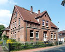
| Latitude 12 52 ° 20 ′ 24 ″ N, 9 ° 39 ′ 55 ″ E |
Residential building | The brick building was erected around 1900. |
|
|
| Nenndorfer Strasse 21 52 ° 20 ′ 38 ″ N, 9 ° 40 ′ 14 ″ E |
Residential building | The brick building was erected around 1900. |

|
|
| Nenndorfer Straße 83 52 ° 20 ′ 25 ″ N, 9 ° 39 ′ 35 ″ E |
Residential building | The representative farmhouse dates from the first half of the 19th century. |
 More pictures |
|
| Stille Straße 9 52 ° 20 ′ 25 ″ N, 9 ° 39 ′ 50 ″ E |
Residential building | The single-storey house was built in 1911. |

|
|
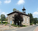
| Stille Straße 6 52 ° 20 ′ 27 ″ N, 9 ° 39 ′ 49 ″ E |
Old chapel | In 1543 a chapel in Empelde was mentioned. It was torn down in 1842/43 and replaced by a sandstone building, which is now used as a district library. |
|
|
| Hansastrasse 55a 52 ° 20 ′ 37 ″ N, 9 ° 38 ′ 36 ″ E |
Buses stone | The Busse stone stood from 1938 to 1995 in the Bürgerholz between Ihme and Ohlendorf. It commemorates the hunter Wilhelm Busse, who was shot in Empelder Holz on May 5, 1842. The stone had to give way to the Empelde potash heap in 1936 . Since 1995 the stone has been standing on a plateau in the southwest of the dump again. |

|
Ihme-Roloven
| location | designation | description |
ID |
image |
|---|---|---|---|---|
| Bettensen 1 52 ° 17 ′ 57 ″ N, 9 ° 39 ′ 50 ″ E |
Well | Rittergut Bettensen with the manor house from the first half or middle of the 18th century. The complex, which probably already existed in the 12th century, was first mentioned in 1439. |

|
|
| Hannoversche Strasse 52 ° 18 ′ 1 ″ N, 9 ° 40 ′ 29 ″ E |
cenotaph |

|
||
| Hannoversche Strasse 4 52 ° 18 ′ 17 ″ N, 9 ° 40 ′ 39 ″ E |
Residential building | The residential building is one of the oldest brick buildings in the area. |

|
|
| Hannoversche Strasse 12 52 ° 18 ′ 12 ″ N, 9 ° 40 ′ 38 ″ E |
Residential building | The house of the Hofstelle is an example of a sugar beet castle. |

|
|
| Hannoversche Strasse 45 52 ° 18 ′ 1 ″ N, 9 ° 40 ′ 28 ″ E |
chapel | The chapel, completed in 1745, is located between the districts of Ihme and Roloven. |

|
|
| Hannoversche Strasse 56 52 ° 17 ′ 55 ″ N, 9 ° 40 ′ 11 ″ E |
Residential building | The house of the Hofstelle is an example of a sugar beet castle. |

|
Relieved
| location | designation | description |
ID |
image |
|---|---|---|---|---|
| Monument path 52 ° 16 ′ 42 ″ N, 9 ° 39 ′ 37 ″ E |
cenotaph | Monument erected in 1850 for Philipp Reinecke (1785–1843) “out of gratitude and admiration”. The top official of the Hanover office had ensured the improvement of the living conditions of the Lindert farmers. |
 More pictures |
|
| Holtenser Strasse 24 52 ° 16 ′ 29 ″ N, 9 ° 39 ′ 38 ″ E |
chapel | Parts of the quarry stone masonry chapel, which was repaired several times, most recently in 2002, is said to be over 700 years old. The current chapel, it is said, was built in 1700. The bell dates from 1758. |
 More pictures |
|
| Lüderser Strasse 52 ° 16 ′ 22 ″ N, 9 ° 39 ′ 37 ″ E |
graveyard | The cemetery is on the outskirts towards Lüdersen. |

|
|
| Schulstrasse 1 52 ° 16 ′ 28 ″ N, 9 ° 39 ′ 39 ″ E |
Former school | The schoolhouse was built in 1825 for the villages of Linderte and Vörie and rebuilt from 1912 to 1919. In 1966 the school was closed. The building then served as an administrative branch and was sold in 1986. |
 More pictures |
Ronnenberg
| location | designation | description |
ID |
image |
|---|---|---|---|---|
| At the Kirchhofe 52 ° 19 ′ 3 ″ N, 9 ° 39 ′ 26 ″ E |
Reformation monument | The monument (1883) is to the north next to the Michaeliskirche. In 1983, on the 500th birthday of Martin Luther, it received an additional commemorative plaque from the (Protestant) Michaelis community and the (Catholic) St. Thomas-More community. |

|
|
| Am Kirchhofe 2 52 ° 19 ′ 1 ″ N, 9 ° 39 ′ 24 ″ E |
Residential building |

|
||
| Am Kirchhofe 3 52 ° 19 ′ 2 ″ N, 9 ° 39 ′ 23 ″ E |
Residential building |

|
||
| Am Kirchhofe 4 52 ° 19 ′ 2 ″ N, 9 ° 39 ′ 21 ″ E |
Residential building |

|
||
| Am Kirchhofe 5 52 ° 19 ′ 3 ″ N, 9 ° 39 ′ 22 ″ E |
Residential building |

|
||
| Am Kirchhofe 6 52 ° 19 ′ 4 ″ N, 9 ° 39 ′ 24 ″ E |
Residential building | The brick building was built around 1870. |

|
|
| Am Kirchhofe 7 52 ° 19 ′ 4 ″ N, 9 ° 39 ′ 26 ″ E |
Residential and commercial building | The half-timbered part of the building was built around 1870, the masonry part around 1900. |

|
|
| Am Kirchhofe 8 52 ° 19 ′ 4 ″ N, 9 ° 39 ′ 25 ″ E |
Residential building | The parish hall was built around 1870. |

|
|
| Am Kirchhofe 9 52 ° 19 ′ 3 ″ N, 9 ° 39 ′ 25 ″ E |
Michaeliskirche |

|
||
| Am Kirchhofe 10 52 ° 19 ′ 0 ″ N, 9 ° 39 ′ 26 ″ E |
school | The Ronnenberg elementary school was built in 1908. |

|
|
| Am Weingarten 52 ° 18 ′ 58 ″ N, 9 ° 39 ′ 15 ″ E |
Jewish Cemetery | The Jewish cemetery was occupied from 1846 to 1933. In 2001 and 2019, three symbolic graves were erected for Jews from Ronnenberg who were expelled and murdered during the Nazi terror. |

|
|
| Am Weingarten 52 ° 18 ′ 58 ″ N, 9 ° 39 ′ 16 ″ E |
cenotaph | Monument to the fallen in the park. |

|
|
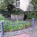
| Am Weingarten 52 ° 18 ′ 59 ″ N, 9 ° 39 ′ 23 ″ E |
Fountain | Old well at the intersection of Hinter dem Dorfe / Mühlenrär / Am Weingarten / Kirchtor |
|
|
| Am Weingarten 2 52 ° 18 ′ 59 ″ N, 9 ° 39 ′ 23 ″ E |
Wall | Quarry stone wall around the property |

|
|
| Deisterstrasse 20 52 ° 18 ′ 53 ″ N, 9 ° 39 ′ 22 ″ E |
Wall | Wall on the corner of the Mühlenrär. | ||
| Empelder Strasse 2A 52 ° 19 ′ 7 ″ N, 9 ° 39 ′ 36 ″ E |
Residential building | The representative house with a decorated gable was built in 1890 by the Jewish Simon Seligmann family. Her butcher's shop was at the bottom left. |

|
|
| Empelder Strasse 20 52 ° 19 ′ 22 ″ N, 9 ° 39 ′ 54 ″ E |
Covering shop | The buildings erected around 1900 are now used by the Ronnenberg road maintenance depot. |

|
|
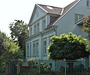
| Gehrdener Strasse 3 52 ° 19 ′ 6 ″ N, 9 ° 39 ′ 8 ″ E |
Residential building | Massive plastered building erected around 1885 |
|
|
| Gehrdener Strasse 15 52 ° 18 ′ 57 ″ N, 9 ° 38 ′ 14 ″ E |
Manor | The manor house of the manor was built in 1864 from plastered quarry stone masonry, the outbuildings in half-timbered construction. |

|
|
| Hagacker 15 52 ° 19 ′ 3 ″ N, 9 ° 39 ′ 1 ″ E |
villa | The potash works villa was built in 1910. |

|
|
| Behind the village 1 52 ° 18 ′ 58 ″ N, 9 ° 39 ′ 26 ″ E |
Residential building |

|
||
| Behind the village 2 52 ° 18 ′ 59 ″ N, 9 ° 39 ′ 26 ″ E |
Residential building |

|
||
| Behind the village 9 52 ° 19 ′ 0 ″ N, 9 ° 39 ′ 31 ″ E |
Residential building |

|
||
| Church gate 4 52 ° 19 ′ 0 ″ N, 9 ° 39 ′ 24 ″ E |
Residential building |

|
||
| Norman Street 3 52 ° 19 ′ 0 ″ N, 9 ° 38 ′ 57 ″ E |
Commercial building | The administration building erected around 1900 was left over from the potash works of the 1975 "Schacht Albert" in Ronnenberg. |

|
|
| Over the Beeken 8b 52 ° 19 ′ 9 ″ N, 9 ° 39 ′ 20 ″ E |
Residential building | According to the inscription, the four-column building was built in 1832. (The Above Beeken 8A building was built in the late 20th century.) |

|
|
| Above the Beeken 13 52 ° 19 ′ 6 ″ N, 9 ° 39 ′ 31 ″ E |
Farmhouse | In 1978, the Ronnenberg local history museum moved into an empty city-owned farm. |

|
Vörie
| location | designation | description |
ID |
image |
|---|---|---|---|---|
| Dorfstrasse 52 ° 16 ′ 56 ″ N, 9 ° 38 ′ 48 ″ E |
Bell tower | In 1543 there was a chapel on Kapellenplatz that no longer existed after the Thirty Years War. In 1863 the two-story brick structure of the bell tower was erected there. |
 More pictures |
|
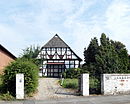
| Dorfstrasse 13 52 ° 16 ′ 54 ″ N, 9 ° 38 ′ 45 ″ E |
Residential building | The four-column house built in the 19th century served as a retirement divider. |
|
|
| Dorfstrasse 21 52 ° 16 ′ 58 ″ N, 9 ° 38 ′ 52 ″ E |
Residential building | The courtyard complex at Dorfstrasse 21 was built around 1900 |

|
|
| Dorfstrasse 23 52 ° 16 ′ 59 ″ N, 9 ° 38 ′ 55 ″ E |
Courtyard | The courtyard complex at Dorfstrasse 23 was built around 1900 |

|
|
| Dorfstrasse 27 52 ° 16 ′ 59 ″ N, 9 ° 38 ′ 55 ″ E |
Courtyard | The courtyard complex at Dorfstrasse 27 was built around 1900. |

|
|
| Landwehrstrasse 16 52 ° 17 ′ 1 ″ N, 9 ° 38 ′ 41 ″ E |
Former wheat mill | The mill on the Landwehr ( Ihme ) was shut down in 1957. A mill stood here as early as 1274. |
 More pictures |
Whet
| location | designation | description |
ID |
image |
|---|---|---|---|---|
| At the Bettenser Berg 52 ° 18 ′ 0 ″ N, 9 ° 38 ′ 37 ″ E |
graveyard | Weetzen cemetery |

|
|
| Bahnhofstrasse 1 52 ° 17 ′ 44 ″ N, 9 ° 38 ′ 3 ″ E |
Residential building |

|
||
| Bahnhofstrasse 9A 52 ° 17 ′ 53 ″ N, 9 ° 38 ′ 9 ″ E |
Reception building | The station building was built in 1909 from Weser sandstone. The Federal Railroad sold the building in 1963. Part of it has been used as a restaurant since 1964. |

|
|
| Bröhnstrasse 47 52 ° 18 ′ 12 ″ N, 9 ° 37 ′ 35 ″ E |
Administration building | Former administration building of the “Germany” shaft. Potash and rock salt were mined here between 1906 and 1922. |

|
|
| Bröhnstrasse 49 52 ° 18 ′ 12 ″ N, 9 ° 37 ′ 32 ″ E |
Factory villa | Former factory villa of the "Germany" shaft. Potash and rock salt were mined here between 1906 and 1922. |

|
|
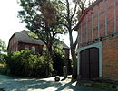
| Engelgasse 1 52 ° 17 ′ 35 ″ N, 9 ° 38 ′ 24 ″ E |
Residential building |
|
||
| Owl Escape 1 52 ° 17 ′ 33 ″ N, 9 ° 38 ′ 26 ″ E |
chapel | The small half-timbered chapel from the 17th century is the oldest building in Weetzen. The bell from 1631 probably does not come from the original chapel, which was donated in 1478. The half-timbered chapel was supposed to be demolished in the early 1970s, but was saved by the "Weetzener Verein für Denkmalpflege eV" and is now used for cultural events. |

|
|
| Owl Escape 5 52 ° 17 ′ 35 ″ N, 9 ° 38 ′ 27 ″ E |
Residential building |

|
||
| Main Street 52 ° 17 ′ 43 ″ N, 9 ° 38 ′ 27 ″ E |
cenotaph | Cenotaph of the Weetzen community for those who have fallen in the wars since 1870 |

|
Disused architectural monuments
| location | designation | description |
ID |
image |
|---|---|---|---|---|
| Benthe Am Wallteich 2, 4, 6, 8, 10, 10a, Bergstr. 14 52 ° 20 ′ 18 ″ N, 9 ° 37 ′ 25 ″ E |
Well | The plot of land of the farm yard was built on compacted. | ||
| Ihme-Roloven, Hannoversche Strasse 2 52 ° 18 ′ 19 ″ N, 9 ° 40 ′ 39 ″ E |
Residential building | The building was erected in 1887 and demolished in 2015. |

|
Remarks
- ↑ referred to as Mühlenrär 1 in the monument topography
literature
- Monument topography Federal Republic of Germany, architectural monuments in Lower Saxony, Hanover district, Volume 13.1, edited by Hans-Herbert Möller , edited by Henner Hannig, Friedrich Vieweg & Son, Braunschweig / Wiesbaden, 1988. ISBN 3-528-06207-X
- Peter Hertel et al. a .: Ronnenberg. Seven Traditions - One City, Ronnenberg 2010, ISBN 978-3-00-030253-4 .
Web links
Commons : Architectural monuments in Ronnenberg - collection of images, videos and audio files
Individual evidence
- ↑ historisches-ronnenberg.de ( Memento from November 2, 2014 in the Internet Archive )
- ↑ The buses - stone in salt turns green , accessed on January 16, 2018

