List of architectural monuments in Seelze
The list of architectural monuments in Seelze contains the architectural monuments of the city of Seelze and the districts Almhorst , Dedensen , Döteberg , Gümmer , Harenberg , Kirchwehren , Lathwehren , Letter , Lohnde , Seelze and Velber in the Hanover region in Lower Saxony . The list is as of 1988.
Almhorst
| location | designation | description |
ID |
image |
|---|---|---|---|---|
| Bröhnfeld 1 52 ° 22 ′ 44 ″ N, 9 ° 33 ′ 48 ″ E |
Residential building | Small four-column frame built in 1853 under a half-hipped roof with partly plastered mud brick lining. |

|
|
| Bröhnfeld 6 52 ° 22 ′ 45 ″ N, 9 ° 33 ′ 44 ″ E |
Residential building | Four posts erected around 1800. |

|
|
| Bröhnfeld 7 52 ° 22 ′ 44 ″ N, 9 ° 33 ′ 43 ″ E |
Residential building | The oldest building in the village, dated 1756. The gable is quite strongly profiled, the compartments lined with red bricks. |

|
|
| Broken hops / Rehwinkel 52 ° 22 ′ 44 ″ N, 9 ° 33 ′ 51 ″ O |
cenotaph |

|
||
| Hop breakage 32 52 ° 22 ′ 45 ″ N, 9 ° 33 ′ 50 ″ E |
Residential building | Four upright dated 1787. |

|
|
| Broken hops 34 52 ° 22 ′ 44 ″ N, 9 ° 33 ′ 50 ″ E |
Residential building | Four-column structure built in 1779 in an important urban area. |

|
|
| Hop breakage 36 52 ° 22 ′ 43 ″ N, 9 ° 33 ′ 47 ″ E |
Residential building | House of the courtyard, built in 1899. One-storey brick building with a bay window on the east eaves. Adorned with gable and eaves cornices, arched windows and a cornice on the gable ends. Sugar beet castle preserved in its original state. |

|
|
| Rehwinkel 1 52 ° 22 ′ 44 ″ N, 9 ° 33 ′ 53 ″ O |
Homestead | Hall house. Erected in 1848. |

|
|
| Rehwinkel 2 52 ° 22 ′ 43 ″ N, 9 ° 33 ′ 50 ″ E |
school | The former village school is a half-timbered hall house in four-column construction. The compartments are lined with red bricks. Due to its location in the middle of the town, it has urban significance and local historical value. |

|
|
| Rehwinkel 3 52 ° 22 ′ 42 ″ N, 9 ° 33 ′ 53 ″ O |
Homestead | The residential building of a sugar beet castle is related to the town's central square. |

|
|
| Rehwinkel 10 52 ° 22 ′ 39 ″ N, 9 ° 33 ′ 55 ″ O |
Homestead | Hall house. Erected in 1825. |

|
Dedensen
| location | designation | description |
ID |
image |
|---|---|---|---|---|
| Old Village 11 52 ° 23 ′ 57 ″ N, 9 ° 30 ′ 54 ″ E |
Residential building | Two-story sugar beet castle from the 1890s. Strictly symmetrical structured by pilaster strips, teardrop-shaped cornices and arched windows. |

|
|
| Old Village 17 52 ° 23 ′ 53 ″ N, 9 ° 30 ′ 54 ″ E |
Residential building | Two-storey sugar beet castle dated 1905. Divided into many parts by decorative brickwork, bay windows and turrets. |

|
|
| Old Village 25 52 ° 23 ′ 55 ″ N, 9 ° 30 ′ 47 ″ E |
school | One-storey school building built from bricks in 1907 right next to the chapel. |

|
|
| Old Village 27 52 ° 23 ′ 57 ″ N, 9 ° 30 ′ 46 ″ E |
chapel | The chapel was built in 1897. Parts of the previous building from 1695, which had been demolished elsewhere, were used in the construction. The design for the chapel comes from Conrad Wilhelm Hase . |

|
|
| Old Village 29 52 ° 23 ′ 59 ″ N, 9 ° 30 ′ 44 ″ E |
Residential building | Two-storey sugar beet castle dated 1909. Divided into many parts with decorative brickwork, bay windows and turrets. |

|
|
| On the dam 12 52 ° 24 ′ 16 ″ N, 9 ° 30 ′ 43 ″ E |
Forester's house | The former forestry office is a two-storey, asymmetrically structured six-axis half-timbered building. Already existed in 1781. |

|
|
| Broad Rehre 1 52 ° 24 ′ 2 ″ N, 9 ° 30 ′ 52 ″ E |
Hall house | Large half-timbered hall house from the second half of the 19th century with redesigned commercial gable. |

|
|
| Unter den Linden 12 52 ° 24 ′ 15 ″ N, 9 ° 31 ′ 3 ″ E |
Residential building | Row buildings built around 1915. Single storey brick houses. The jambs are decorated with inlaid plaster fields. A row of linden trees complements the group of structures. |

|
|
| Unter den Linden 14 52 ° 24 ′ 16 ″ N, 9 ° 31 ′ 4 ″ E |
Residential building | Row buildings built around 1915. Single storey brick houses. The jambs are decorated with inlaid plaster fields. A row of linden trees complements the group of structures. |

|
|
| Unter den Linden 16 52 ° 24 ′ 16 ″ N, 9 ° 31 ′ 5 ″ E |
Residential building | Row buildings built around 1915. Single storey brick houses. The jambs are decorated with inlaid plaster fields. A row of linden trees complements the group of structures. |

|
|
| Unter den Linden 18 52 ° 24 ′ 16 ″ N, 9 ° 31 ′ 5 ″ E |
Residential building | Row buildings built around 1915. Single storey brick houses. The jambs are decorated with inlaid plaster fields. A row of linden trees complements the group of structures. |

|
|
| Unter den Linden 20 52 ° 24 ′ 17 ″ N, 9 ° 31 ′ 5 ″ E |
Residential building | Row buildings built around 1915. Single storey brick houses. The jambs are decorated with inlaid plaster fields. A row of linden trees complements the group of structures. |

|
|
| Unter den Linden 22 52 ° 24 ′ 17 ″ N, 9 ° 31 ′ 6 ″ E |
Residential building | Row buildings built around 1915. Single storey brick houses. The jambs are decorated with inlaid plaster fields. A row of linden trees complements the group of structures. |

|
Döteberg
| location | designation | description |
ID |
image |
|---|---|---|---|---|
| Arnekestrasse 3 52 ° 22 ′ 20 ″ N, 9 ° 35 ′ 25 ″ E |
Residential / farm buildings | The oldest building in town, built in 1734. Four-column construction under a gable roof with a crooked hip and double cantilever gable. Oak framework lined with red bricks. |

|
|
| Dorfstrasse 4 52 ° 22 ′ 26 ″ N, 9 ° 35 ′ 30 ″ E |
Courtyard | Group of buildings, including trees and fences, designated as a monument. The longitudinal barn is dated 1808, the four-column main house in 1844. |

|
|
| Kirchbuschweg 1 52 ° 22 ′ 26 ″ N, 9 ° 35 ′ 32 ″ E |
Residential building | The brick building erected in 1904 is a sugar beet castle. Excellent for its location, size, shape and state of preservation. |

|
|
| Lange Straße 9 52 ° 22 ′ 21 ″ N, 9 ° 35 ′ 32 ″ E |
Residential building | Three-column building with urban significance, built around 1800 as a senior citizen. |

|
|
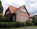
| Lange Straße 13 52 ° 22 ′ 20 ″ N, 9 ° 35 ′ 30 ″ E |
Residential building | Hall house dated 1786 with regular half-timbering under a half-hipped roof. |
|
Gümmer
| location | designation | description |
ID |
image |
|---|---|---|---|---|
| Am Zollkrug 1 52 ° 24 ′ 27 ″ N, 9 ° 32 ′ 5 ″ E |
Barn system | Brick barn building. Erected at the end of the 19th century. | ||
| Am Zollkrug 6 52 ° 24 ′ 30 ″ N, 9 ° 32 ′ 6 ″ E |
Residential building | Commercial building with cross board. Erected in the old town center in the first half of the 19th century. | ||
| Glockengasse 52 ° 24 ′ 30 ″ N, 9 ° 32 ′ 0 ″ E |
chapel | Plastered quarry stone building on a sandstone base with buttresses made of bricks and a three-eight choir in the east. Dated 1508 above the pointed arched door on the north side, which is clad in sandstone. Gable roof with half-hip and small turret. Interior with ribbed vault. |
 More pictures |
|
| Osnabrücker Landstrasse 9 52 ° 24 ′ 26 ″ N, 9 ° 32 ′ 3 ″ E |
Four-column construction | The hall house in four-column construction is one of the few surviving half-timbered buildings, dated 1787 on the floorboard. Agricultural building converted for residential purposes. | ||
| Osnabrücker Landstrasse 20 52 ° 24 ′ 33 ″ N, 9 ° 31 ′ 51 ″ E |
Courtyard | Courtyard, built uniformly from red bricks. The bay window of the house is dated 1905. Enclosed complex with stable, barn and brick wall facing the street. With toothed friezes and arched door and window openings as the same structural and decorative elements. | ||
| Red row 52 ° 24 ′ 21 ″ N, 9 ° 32 ′ 5 ″ E |
monument | World War Memorial in the cemetery |
Harenberg
| location | designation | description |
ID |
image |
|---|---|---|---|---|
| Harenberger Meile 14 52 ° 22 ′ 43 ″ N, 9 ° 37 ′ 16 ″ E |
church | Barbarakirche. Protestant parish church built in the neo-Gothic style in 1882 as a replacement for an old chapel that had been demolished at the same location in the center of the town, according to plans by Conrad Wilhelm Hase . Inside is a carved altar from the first half of the 16th century. |
 More pictures |
|
| Harenberger Meile 16 52 ° 22 ′ 44 ″ N, 9 ° 37 ′ 14 ″ E |
||||
| Harenberger Meile 28 52 ° 22 ′ 41 ″ N, 9 ° 36 ′ 59 ″ E |
Courtyard | Two-storey residential building of a sugar beet castle built around 1900 in an exposed urban area. The facade is divided by gabled houses, cornices, brickwork, trusses and arched window openings. | ||
| Harenberg Mile 33 52 ° 22 ′ 41 ″ N, 9 ° 37 ′ 14 ″ E |
Residential / farm buildings | The main building of the yard is a hall house built in 1830 in four-column construction with regular half-timbering. | ||
| Höfestraße 1 52 ° 22 ′ 42 ″ N, 9 ° 37 ′ 13 ″ E |
Courtyard | Two-storey residential building of a sugar beet castle built around 1900 in an exposed urban area. The facade is divided by gabled houses, cornices, brickwork, trusses and arched window openings. | ||
| Höfestraße 12 52 ° 22 ′ 43 ″ N, 9 ° 37 ′ 1 ″ E |
Longitudinal barn | Elongated building erected in 1862 with a red-bricked partition under a gable roof. |
Church brigades
| location | designation | description |
ID |
image |
|---|---|---|---|---|
| Kirchwehrener Ring 6 52 ° 22 ′ 2 ″ N, 9 ° 34 ′ 2 ″ E |
church | The Dreieinigkeitskirche, built in the same place from 1753 to 1755 as a replacement for a dilapidated predecessor built after 1500. The remaining late Romanesque lower half of the tower on a square floor plan was already part of a fortified church possibly built around 1200 . The grave of the Dunau manor was in the church until 1875. A plastered hall church built from quarry stone with corner blocks with three-eighth closure in the east. Sandstone-clad flat arched window openings. Interior with a horizontal ceiling. Wooden pulpit altar created by Johann Friedrich Blasius Ziesenis in 1755 . |
 More pictures |
|
| Kirchwehrener Ring 6 52 ° 22 ′ 2 ″ N, 9 ° 34 ′ 2 ″ E |
Churchyard | The place around the church was the burial place of the residents of Kirchwehren (until 1878), Lathwehren (until 1856) and earlier Esedinghausen . |

|
|
| Lenther Strasse 52 ° 21 ′ 34 ″ N, 9 ° 34 ′ 41 ″ E |
monument | Probably built at the instigation of the forester Pieper on the edge of the Bössel forest south of the forester's house. Inscription “In memory of the forest director Dr. Dedicated to Burckhardt ”,“ 1880 ”. |

|
|
| Easter end 8 52 ° 21 ′ 58 ″ N, 9 ° 34 ′ 12 ″ E |
Hall house | Hall building built in 1897 in four-column construction. The gable facing the street is structured with a cornice, teardrop-shaped gable cornice and arched door and window openings. |

|
Lathwehren
| location | designation | description |
ID |
image |
|---|---|---|---|---|
| On the Dunau 1 52 ° 21 ′ 16 ″ N, 9 ° 32 ′ 59 ″ E |
Good Dunau | Two-storey manor house in quarry stone from the first half of the 17th century, built on the foundations of a moated castle on the Möseke . Closed complex with hereditary burial, park with valuable trees and a large farm yard with half-timbered and brick buildings. |

|
|
| On the Dunau 52 ° 21 ′ 17 ″ N, 9 ° 32 ′ 54 ″ E |
Manor mill | In the middle of the 19th century in quarry stone, four-storey Dutch windmill with a rectangular floor plan was built on the octagonal mill stump of the previous water mill. The hull of the mill is hung with red bricks, the gallery no longer exists. Well-preserved mill hood with winged cross and bracket for the compass rose. |

|
|
| On the bike 1 52 ° 21 ′ 40 ″ N, 9 ° 32 ′ 29 ″ E |
Part of a group of structures in the village center. | |||
| On the wheel 2 52 ° 21 ′ 40 ″ N, 9 ° 32 ′ 28 ″ E |
Half-timbered building | Small half-timbered building erected at the beginning of the 19th century and rebuilt around 1900 in an exposed urban area. Probably the school house earlier. Central component of a group of structures in the village center. | ||
| On the wheel 4 52 ° 21 ′ 39 ″ N, 9 ° 32 ′ 27 ″ E |
Courtyard | Residential building in four-column construction, dated 1807. The gables of the main house and the longitudinal barn delimit the group of structures in the village center in the south-west. Long barn along Poggenhuhnsweg. | ||
| On the wheel 6 52 ° 21 ′ 38 ″ N, 9 ° 32 ′ 28 ″ E |
Part of a group of structures in the village center. | |||
| On the bike 10 52 ° 21 ′ 38 ″ N, 9 ° 32 ′ 30 ″ E |
Part of a group of structures in the village center. | |||
| Georgstrasse 2 52 ° 21 ′ 42 ″ N, 9 ° 32 ′ 36 ″ E |
Residential / farm buildings | Age divider. Completely originally preserved, simple four-column stand on an almost square floor plan under a gable roof with a half-hip. Erected in the middle of the 19th century. |

|
|
| Georgstrasse 11 52 ° 21 ′ 41 ″ N, 9 ° 32 ′ 29 ″ E |
Courtyard | Part of a group of structures in the village center. | ||
| Georgstrasse 13 52 ° 21 ′ 41 ″ N, 9 ° 32 ′ 27 ″ E |
Courtyard | 1842 in half-timbered construction erected transverse drive-through barn with eaves, slightly set back the brick building erected in 1904. North-western boundary and components of a group of structures in the village center. | ||
| Mosenweg 52 ° 21 ′ 42 ″ N, 9 ° 32 ′ 38 ″ E |
cenotaph |

|
||
| Poggenhuhnweg 4 52 ° 21 ′ 37 ″ N, 9 ° 32 ′ 23 ″ E |
Yard | Former main house of a farmyard built in 1796. Converted for residential purposes. |

|
|
| To Röselhof 6 52 ° 21 ′ 39 ″ N, 9 ° 32 ′ 25 ″ E |
Part of a group of structures in the village center. | |||
| To Röselhof 7 52 ° 21 ′ 40 ″ N, 9 ° 32 ′ 18 ″ E |
Part of a group of structures in the village center. |
Letter
| location | designation | description |
ID |
image |
|---|---|---|---|---|
| Ebertstrasse 11-19, 10-20 52 ° 23 ′ 45 ″ N, 9 ° 38 ′ 20 ″ E |
Cooperative settlement | Closed row of three-storey plastered houses on both sides of the street, built around 1920 by the Letter building cooperative. |

|
|
| Im Sande 4 52 ° 23 ′ 58 ″ N, 9 ° 38 ′ 45 ″ E |
Kötnerhaus | Kötnerhaus. Simple hall house in half-timbered construction. In the hall gate dated 1743, thus the oldest building Letters. |

|
|
| Im Sande 6 52 ° 23 ′ 58 ″ N, 9 ° 38 ′ 44 ″ E |
school | Kötnerhaus. Simple hall house in half-timbered construction. In the hall gate dated 1786. Significance in local history as a former school building. |

|
|
| Im Sande 14 52 ° 23 ′ 58 ″ N, 9 ° 38 ′ 37 ″ E |
Residential farm building | Part of a group of structures, a row of four four-column structures, erected in the mid-19th century. Until 2018 this building was the Heimatmuseum Seelze . |
 More pictures |
|
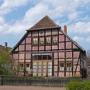
| Im Sande 16 52 ° 23 ′ 57 ″ N, 9 ° 38 ′ 36 ″ E |
Residential farm building | Part of a group of structures, a row of four four-column structures, erected in the mid-19th century. |
|
|
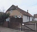
| Im Sande 18 52 ° 23 ′ 58 ″ N, 9 ° 38 ′ 35 ″ E |
Residential farm building | Part of a group of structures, a row of four four-column structures, erected in the mid-19th century. |
|
|
| Im Sande 20 52 ° 23 ′ 57 ″ N, 9 ° 38 ′ 34 ″ E |
Residential farm building | Part of a group of structures, a row of four four-column structures, erected in the mid-19th century. |

|
|
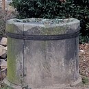
| In the sand 52 ° 23 ′ 55 ″ N, 9 ° 38 ′ 30 ″ E |
Fountain | The Wulfes fountain dated 1624. Allegedly during the Thirty Years' War the mercenaries used their weapons against him in order to be invulnerable. |
|
|
| In the sand 52 ° 23 ′ 53 ″ N, 9 ° 38 ′ 21 ″ E |
graveyard | The Im Sande cemetery is protected in accordance with Section 3 (3) NDSchG. |

|
|
| Lange Feldstrasse 117 52 ° 23 ′ 36 ″ N, 9 ° 37 ′ 25 ″ E |
Double residential building | Double house built around 1910 by the railway to accommodate the engine drivers. Lateral wings and loft-like additions in half-timbering. (left half) |

|
|
| Lange Feldstrasse 119 52 ° 23 ′ 36 ″ N, 9 ° 37 ′ 25 ″ E |
Double residential building | Double house built around 1910 by the railway to accommodate the engine drivers. Lateral wings and loft-like additions in half-timbering. (right half) |

|
|
| Lange Feldstrasse 121 52 ° 23 ′ 35 ″ N, 9 ° 37 ′ 22 ″ E |
Administration building | Three-storey administration building erected by the railway around 1910. Plastered building on rubble stone plinth with central projection under a gable roof, indicated side wings under a hipped roof. |

|
|
| Stöckener Strasse 16 52 ° 23 ′ 56 ″ N, 9 ° 38 ′ 49 ″ E |
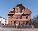
Residential building | House built around 1900 in brick construction. Two-storey building on the eaves with a small hip and central bay window. Elaborately decorated and symmetrically structured by glazed bricks, brick decorations, surrounding cornices, and small roofs over the arched window openings. |
|
Wages
| location | designation | description |
ID |
image |
|---|---|---|---|---|
| At the monument 52 ° 23 ′ 59 ″ N, 9 ° 33 ′ 45 ″ E |
monument | A boulder as a memorial for those who died in World War II. |

|
|
| Am Wall 4 52 ° 24 ′ 20 ″ N, 9 ° 33 ′ 27 ″ E |
Longitudinal barn | The longitudinal barn from the second half of the 18th century is one of the oldest buildings in Lohnde and is of historical interest because of its prominent urban location. |

|
|
| Beekestrasse 11 52 ° 24 ′ 8 ″ N, 9 ° 33 ′ 27 ″ E |
Wall stand construction | Two-story, small, half-timbered wall stud construction from the first half of the 19th century. On the southern edge of the town center directly on the Beeke | ||
| Ferry route 52 ° 24 ′ 19 ″ N, 9 ° 33 ′ 41 ″ E |
bridge | Three-hinged arch bridge built in 1912 from reinforced concrete |
 More pictures |
|
| In the gray area 8 52 ° 24 ′ 14 ″ N, 9 ° 33 ′ 33 ″ E |
Main house in the courtyard | Building erected around 1800. The strong, square compartment is lined with red bricks. |

|
|
| Krumme Masch 18 52 ° 23 ′ 51 ″ N, 9 ° 34 ′ 20 ″ E |
Cross stone | Cross stone offset during the construction of the Mittelland Canal on private property. According to legend, in memory of Dietrich von Mandelsloh, who was stabbed to death at his location in 1386. |
 More pictures |
|
| Lohnder Strasse 20 52 ° 24 ′ 9 ″ N, 9 ° 33 ′ 36 ″ E |
Courtyard | Group of structural facilities: Large-volume residential building with a steep gable in half-timbering with red brick lining, barn in target construction and farm building as half-timbered wall stud from around 1800. | ||
| Lohnder Strasse 24 52 ° 24 ′ 10 ″ N, 9 ° 33 ′ 31 ″ E |
Courtyard | Group of structures from the main house, barn and outbuildings, as well as the neighboring old-age divider. | ||
| Lohnder Strasse 24 A 52 ° 24 ′ 9 ″ N, 9 ° 33 ′ 32 ″ E |
Hall house | Age divider. Four-post with a flat gable built in 1834. |
Seelze
| location | designation | description |
ID |
image |
|---|---|---|---|---|
| On Junkernwiese 44 52 ° 23 '52 "N, 9 ° 35' 48" E |
Hall house | After the great fire of 1755 in Seelze, a four-column building was built. The hall beam is embossed with the lettering 1757. |

|
|
| Bonhoefferstraße 2 52 ° 23 ′ 45 ″ N, 9 ° 35 ′ 42 ″ E |
Residential building | Single-storey residential building with an extended mansard roof, built around 1912. |

|
|
| Bremer Strasse 7 52 ° 23 ′ 51 ″ N, 9 ° 35 ′ 30 ″ E |
Courtyard | Residential / farm building built in 1833. | ||
| Bremer Strasse 10 52 ° 23 ′ 52 ″ N, 9 ° 35 ′ 34 ″ E |
Residential and commercial building | Residential and commercial building built in 1902. Former restaurant. | ||
| Bremer Strasse 13 52 ° 23 ′ 38 ″ N, 9 ° 35 ′ 32 ″ E |
Yard | The red stone building was built around 1900, the house is part of a former courtyard. The longitudinal barn built around 1800 is one of the last half-timbered barns in Seelze. |

|
|
| Bremer Strasse 14 52 ° 23 ′ 52 ″ N, 9 ° 35 ′ 36 ″ E |
Hall house | The residential / farm building erected in 1658 is the oldest building in Seelze. Only slightly changed and therefore of national monument conservation importance. | ||
| Bremer Strasse 19 52 ° 23 ′ 53 ″ N, 9 ° 35 ′ 33 ″ E |
Yard | The residential building, dated 1848 in the hall beam, was converted for residential purposes around 1900. Around 1870, the almost equal-sized barn parallel to the ridge was built in brick construction with arched gate and window openings. | ||
| Kolbestrasse 1 52 ° 23 ′ 52 ″ N, 9 ° 35 ′ 42 ″ E |
Hall house | Hall building in four-column construction. Half-timbered gables, red tiles and roof tiles. | ||
| Kolbestrasse 9 52 ° 23 ′ 52 ″ N, 9 ° 35 ′ 39 ″ E |
Wall stand construction | Small wall stand erected around 1800 with a lateral longitudinal entrance under a gable roof. | ||
| Hannoversche Strasse 13 52 ° 23 ′ 46 ″ N, 9 ° 35 ′ 37 ″ E |
Old village mug | Old pitcher. The hall beam is dated 1687, making it the second oldest building in Seelze. Two-story wall stand construction. Since 2018 the seat of the Heimatmuseum Seelze . |

|
|
| Hannoversche Strasse 24 52 ° 23 ′ 41 ″ N, 9 ° 35 ′ 42 ″ E |
school-building | The former schoolhouse, built in 1903, was converted into the Seelz town hall in the 1990s with an extension. |

|
|
| Hannoversche Strasse 26 52 ° 23 ′ 39 ″ N, 9 ° 35 ′ 45 ″ E |
graveyard | The cemetery on Hannoversche Straße is protected according to Section 3 (3) NDSchG. |

|
|
| Hannoversche Strasse 52 ° 23 ′ 40 ″ N, 9 ° 35 ′ 57 ″ E |
Obentraut monument | In memory of Hans Michael Elias von Obentraut, a sandstone pyramid created by Jeremias Sutel in 1630, crowned by a ball with an iron cross. |
 More pictures |
|
| Hannoversche Strasse 54 52 ° 23 ′ 38 ″ N, 9 ° 36 ′ 9 ″ E |
Residential building | |||
| Hannoversche Strasse 64 52 ° 23 ′ 34 ″ N, 9 ° 36 ′ 18 ″ E |
villa | Around 1900 for Gerhard Lösekann, co-owner of the chemical factory Mercklin & Lösekann, two-storey villa built, later also named after its changing owners: Villa Lösekann; Villa Oesterheld; Villa lead red. |

|
|
| Marienstraße 3 52 ° 23 ′ 44 ″ N, 9 ° 35 ′ 27 ″ E |
Residential building | Two-storey plastered house built in 1912 with an extended mansard roof. |

|
|
| Martinskirchstrasse 52 ° 23 ′ 51 ″ N, 9 ° 35 ′ 47 ″ E |
St. Martin Church |
 More pictures |
||
| Martinskirchstrasse 52 ° 23 ′ 51 ″ N, 9 ° 35 ′ 45 ″ E |
cenotaph |

|
||
| Martinskirchstrasse 9 52 ° 23 ′ 53 ″ N, 9 ° 35 ′ 46 ″ E |
school | The former school is a brick building built around 1900. Current use as a daycare center. | ||
| Martinskirchstrasse 10 52 ° 23 ′ 54 ″ N, 9 ° 35 ′ 44 ″ E |
Rectory | Two-story wall stud construction from the 18th century with conversions from the 19th century. |

|
|
| Martinskirchstrasse 20 52 ° 23 ′ 49 ″ N, 9 ° 35 ′ 50 ″ E |
Longitudinal barn |

|
||
| Mittelland Canal 52 ° 24 ′ 14 ″ N, 9 ° 35 ′ 3 ″ E |
Trough bridge | Steel trough bridge with segment arches. Part of the old route of the Mittelland Canal over the Leine, completed in 1917 . |
 More pictures |
|
| Mittelland Canal 52 ° 24 ′ 24 ″ N, 9 ° 35 ′ 26 ″ E |
Trough bridge | Steel trough bridge with segment arches. Part of the old route of the Mittelland Canal, completed in 1917, over the floodplain to the right of the Leine. |
More pictures |
|
| Südstrasse 9 (corner of Hindenburgstrasse) 52 ° 23 ′ 38 ″ N, 9 ° 35 ′ 23 ″ E |
Trinity Church | Catholic Church, built in 1913, expanded in 1970, interior design by Gerd Winner . |
 More pictures |
|
| Ulmenstrasse 20 52 ° 23 ′ 50 ″ N, 9 ° 34 ′ 55 ″ E |
Company apartments | Two-storey plastered building built around 1915 with Art Nouveau elements in the stairwell. |

|
|
| Ulmenstrasse 22 52 ° 23 ′ 47 ″ N, 9 ° 35 ′ 1 ″ E |
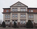
Company apartments | Two-storey plastered building built around 1915 with Art Nouveau elements in the stairwell. |
|
|
| Wunstorfer Strasse 40 52 ° 23 ′ 50 ″ N, 9 ° 34 ′ 55 ″ E |
Factory buildings | The Riedel-de-Haen company was relocated from Hanover to Seelze. Administration building erected around 1890. Two- and three-storey brick buildings, structured by pilaster strips, eaves and gable cornices and window fields with Gothic style elements. |

|
Velber
| location | designation | description |
ID |
image |
|---|---|---|---|---|
| Am Wehrgraben 1 52 ° 22 ′ 11 ″ N, 9 ° 39 ′ 0 ″ E |
Courtyard | Almost completely preserved courtyard with the main house, outbuildings, trees, enclosure, farm garden, orchard and calf meadow. The mighty main house, dated 1796 in the gate beam, is a Low German hall house in four-column construction under a gable roof with a half-hip. | ||
| Kapellenbrink 1 52 ° 22 ′ 12 ″ N, 9 ° 39 ′ 2 ″ E |
school | Simple, single-storey, massive brick building with a red clay pan roof, erected in 1892. The separate teacher's house was demolished in 1982. | ||
| Kapellenbrink 3 52 ° 22 ′ 12 ″ N, 9 ° 39 ′ 3 ″ E |
chapel | Gothic chapel with three-sided choir in the east, almost completely rebuilt in 1841. White brickwork on a sandstone foundation, gable roof with a small square roof turret. A late medieval cross stone is walled in inside. A valuable three-winged altar dates from 1610. |
 More pictures |
|
| Steinkamp 1 52 ° 22 ′ 18 ″ N, 9 ° 39 ′ 3 ″ E |
Residential / farm buildings | One-storey brick building built around 1900 with a two-storey bay house and farm building attached to the rear left. Strictly symmetrical structure littered with numerous ornamental shapes. | ||
| Steinkamp 52 ° 22 ′ 20 ″ N, 9 ° 39 ′ 23 ″ E |
cenotaph | Cenotaph in the entrance area of the cemetery |

|
|
| At the English Cemetery 52 ° 22 ′ 40 ″ N, 9 ° 39 ′ 13 ″ E |
Military cemetery | The English cemetery is protected according to $ 3 (3) NDSchG. |
 More pictures |
Disused architectural monuments
| location | designation | description |
ID |
image |
|---|---|---|---|---|
| Almhorst, Hatefeld 2 52 ° 22 ′ 49 ″ N, 9 ° 34 ′ 16 ″ E |
Homestead | Hall building in four-column construction. Erected between 1864 and 1866, demolished in the 1990s, there are new buildings here. |

|
|
| Almhorst, Hatefeld 4 52 ° 22 ′ 49 ″ N, 9 ° 34 ′ 15 ″ E |
Homestead | Hall building in four-column construction. Erected between 1864 and 1866, demolished in the 1990s, there are new buildings here. |

|
|
| Almhorst, Hatefeld 6 52 ° 22 ′ 48 ″ N, 9 ° 34 ′ 15 ″ E |
Homestead | Hall building in four-column construction. Erected between 1864 and 1866, demolished in the 1990s, there are new buildings here. |

|
|
| Almhorst, Rehwinkel 5 52 ° 22 ′ 43 ″ N, 9 ° 33 ′ 56 ″ E |
Homestead | Rear part of the Rehwinkel 3 courtyard area. Apparently there is a new building here. |

|
|
| Kirchwehren, Küsterstrasse 13 52 ° 22 ′ 3 ″ N, 9 ° 34 ′ 1 ″ E |
Village school | Schoolhouse built in 1898 on the edge of the churchyard. Closed from 1941 to 1945 due to lack of teachers. After the completion of a new school building, it has been used as a community cold store since 1954. Listed as a historical monument in the 1980s, it was later demolished. 2019 a green meadow. |

|
|
| Lohnde, Im Grauland 11 52 ° 24 ′ 15 ″ N, 9 ° 33 ′ 36 ″ E |
Longitudinal barn | The longitudinal barn from the second half of the 18th century was one of the oldest buildings in Lohndes in 1988 and also of monumental interest because of its prominent urban location. In 2019 there is a shelter here. |

|
|
| Seelze, Martinskirchstrasse 11 52 ° 23 ′ 52 ″ N, 9 ° 35 ′ 45 ″ E |
Sexton house | A simple brick building built around 1900 was listed as a historical monument. This was canceled in 2006. The new parish hall was built here. |

|
|
| Seelze, Martinskirchstrasse 16 52 ° 23 ′ 49 ″ N, 9 ° 35 ′ 45 ″ E |
Parish widow house | A four-column building built in 1756 was a listed building. A new building will be built here in 2019. |

|
literature
- Hans-Herbert Möller (Ed.), Henner Hannig (Editing): District of Hanover. (= Monument topography Federal Republic of Germany , architectural monuments in Lower Saxony , Volume 13.1.) Friedrich Vieweg & Sohn, Braunschweig / Wiesbaden, 1988, ISBN 3-528-06207-X .
Web links
Commons : Architectural monuments in Seelze - Collection of images, videos and audio files
Individual evidence
- ↑ Chronicle of the Alten Kruges in Seelze , www.seelze.de, accessed on April 3, 2019.
- ^ Norbert Saul, Stadtarchiv: Ortsgeschichte Kirchwehren , www.seelze.de, accessed on April 3, 2019.
- ↑ Norbert Saul, Seelze City Archives: Seelze's old sexton and school house , www.seelze.de, accessed on April 3, 2019.

