
Harenberg (Seelze)
|
Harenberg
City of Seelze
|
|
|---|---|
 |
|
| Height : | 72 m above sea level NHN |
| Area : | 50 ha |
| Residents : | 1743 (December 31, 2018) |
| Population density : | 3,486 inhabitants / km² |
| Incorporation : | March 1, 1974 |
| Postal code : | 30926 |
| Area code : | 05137 |

Harenberg is a district of the city of Seelze . With 1743 inhabitants, Harenberg is one of the smaller districts of Seelze. The district is near Hanover .
geography
Harenberg is located around three kilometers from the city limits of Hanover and near the federal highway 441 . The place is located within the flat landscape on a hill, from which one has a wide view of the surroundings, including Seelze and Hanover as well as the Deister . Harenberg has three smaller settlement areas outside the village. These are the residential areas Kollrothshöh, Friedhof and Mühle, which are located on the historic access roads of Harenberg.
history
The time when the town was founded is not known. The first references to the town of Harenberg can be found in documents from Hildesheim from 1195 and 1211 . However, this is not clear because of the spelling of the place name. The first reliable documentary mention comes from 1220.
On March 1, 1974, Harenberg was incorporated into the town of Seelze.
politics
Local council
The local council of Harenberg consists of 7 councilors and councilors.
| CDU | SPD | Green | total | |
| 2011 | 4th | 2 | 1 | 7 seats |
Status: Local election on September 11, 2011
The local mayor is Wilhelm Lohmann (CDU).
coat of arms
The local coat of arms, with the three roses in the head of the shield, is based on the coat of arms of the Counts of Hallermund , whose main rulership was in the area around the Deister . In the 13th century, the von Hallermunds owned family property in Harenberg, which among other things fell to the Marienwerder monastery in 1220 (gift from Count Burchard von Oldenburg from his mother Beatrix von Hallermund's inheritance). After the foundation of the coat of arms of the graphic artist and heraldist Alfred Brecht in 1962, the scythes stand for the rural character of the village and the bee (Imme) is reminiscent of the nearby desert .
Culture and sights
- Neo-Gothic St. Barbara Church from 1882, replaced a half-timbered chapel
- "Meiers Mühle" from 1684, was operated electrically from 1948 to around 1980
- Hannover War Cemetery as a British war cemetery right on the border with the Hanover district of Ahlem

Barbarakirche
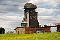
Mill near Harenberg

Hannover War Cemetery , behind it Ahlemer Höhe
_IMG_7271.jpg)
_IMG_7285.jpg)

Web links
Individual evidence
- ↑ City portrait - population figures. Website of the city of Seelze, accessed on October 20, 2019 .
- ^ Federal Statistical Office (ed.): Historical municipality directory for the Federal Republic of Germany. Name, border and key number changes in municipalities, counties and administrative districts from May 27, 1970 to December 31, 1982 . W. Kohlhammer GmbH, Stuttgart / Mainz 1983, ISBN 3-17-003263-1 , p. 196 .