
Gjáin
| Gjáin | ||
|---|---|---|
 View over the upper valley (left the northern fall of Gjárfoss) |
||
| location | Southurland , Iceland | |
| Geographical location | 64 ° 9 ′ 5 ″ N , 19 ° 44 ′ 18 ″ W | |
|
||
| height | 180 m | |
| particularities | numerous waterfalls | |

Gjáin ( Icelandic for the canyon ) is a short valley area in southern Iceland with numerous smaller waterfalls of the Rauðá river . The Gjárfoss waterfall is located at the upper basin- like depression . In the vicinity of Gjáin lies the historic farmstead of Stöng , which was buried under ash when the nearby volcano Hekla erupted in 1104. Based on the remains excavated in 1939, three medieval courtyard buildings were reconstructed a few kilometers away as Þjóðveldisbær in 1974 .
On the half-hour hiking trail in Þjórsárdalur from Stöng to the small Gjáin gorge, it is possible to take a look at the volcano from time to time.
A larger 5-6 hour hike continues to Háifoss , the third highest waterfall in Iceland.

Overview of the valley

River and waterfalls in the valley
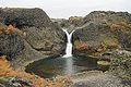
Gjárfoss in the basalt of the Gjáin

