Þjórsárdalur
The Þjórsárdalur is a valley in the south of Iceland .
Name and river
The valley is touched by Iceland's longest river, the Þjórsá , which is where the name comes from.
Location and shape
The Þjórsárdalur is the easternmost valley in the Árnessýsla district . It is located north of Gaukshöfði between the small mountains Hagafjall and Búrfell (Þjórsá) .
A large part of the valley is a barren sandy desert, thanks to the frequent eruptions of the nearby volcano Hekla .
However, the State Forestry Association ( Skógrækt ríkisins ) has been working on reforestation and soil consolidation since the 1930s. This can be seen from the Skriðufell. In addition to planting trees, lupins and beach grass were also sown.
Volcanism
Hekla
In the Middle Ages, the valley was relatively densely populated. However, a huge explosive eruption of the Hekla in 1104 put an end to this. The 20 or so farms that were buried under ash at the time were partially excavated again in 1939, including the Stöng museum farm , the reconstruction of which Þjóðveldisbær is now located near the Búrfellsstöð power station.
Traces of an even more powerful eruption of the Hekla can also be found in the valley: The whitish rhyolite ashes of this Plinian eruption , which occurred about 2,900 years ago, can still be found on the mountain slopes of the area and on Skeljafjall the layer is about 2 , 5 m thick.
Bárðarbunga
In addition to the Hekla, other volcanic systems have also influenced the shape of the valley. This applies above all to the Bárðarbunga system , which has sent lavas down into the lowlands over the rows of craters of Vatnaöldur and Veiðivötn in the Icelandic highlands .
Above all, we are talking about the Búrfellslaves, who streamed out of the Tungnaá basin 3,500 years ago and a. cover the bottom of the valley. These lavas also formed the pseudocraters in the interior of the valley when they ran over wet moorland .
The lavas poured into the Þjórsárdalur through a small gorge called Gjáin .
Cold central volcano
For example, below the Háifoss waterfall you can see the remains of an old central volcano that has cooled down. Therefore, rhyolite can also be found in the vicinity of the waterfall.
The Þjórsardalur was practically cut into the volcano, which was later given the name of the valley. Strictly speaking, geologically speaking, the valley is the remains of a caldera about 8 km in diameter, as can be seen particularly beautifully at Mount Fossalda , where many tunnels have dug into older rhyolite and andesite rock. These conveyor channels ( dykes ) connect the magma chamber with small rhyolite vadomes.
In addition to Tillit rock , you will also find pillow lavas and andesite tuffs in the valley . This in turn indicates that when the volcano was still active about 2 million years ago, a glacier filled the caldera at the same time.
Various basalt lava flows from other sources buried the remains of the volcano until the glaciers of the Ice Age eroded them and partially brought it back to daylight.
Rivers
The eponymous Þjórsá actually only touches the valley on its south side. In the valley itself, however, there are four rivers: Fossá í Þjórsárdal , which forms the beautiful waterfalls Háifoss and Hjálparfoss , and Rauðá , Sandá and Grjótá .
Búrfellsstöð power station
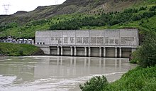
The large hydropower plant Búrfellsstöð was put into operation in 1972. It lies below the Samstaðamúli. The turbine house is located there and a small village of the employees and workers located there has emerged nearby. A swimming pool was built for them in Reykholt in Þjórsádalur, which is still in use.
See also
Individual evidence
- ↑ Íslandshandbókin. 2. bindi. 1989, p. 845
- ↑ Þjórsárdalur in the Global Volcanism Program of the Smithsonian Institution (English), according to "Hekla - Eruptive History" at GVP a VEI 5; Retrieved February 25, 2011
- ↑ Íslandshandbókin, ibid.
- ↑ Thor Thordarsson, Armann Hoskuldsson: Iceland. Classic Geology in Europe 3. Harpenden 2002, p. 85
- ↑ Thor Thordarsson, ibid., P. 85
- ↑ Thor Thordarsson, Armann Hoskuldsson: Iceland. Classic Geology in Europe 3. Harpenden 2002, pp. 84f.
- ↑ Íslandshandbókin, ibid., P. 846


