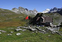
Glattalp
The Glattalp is located in a hollow above Bisisthal in the canton of Schwyz in the municipality of Muotathal .
climate
Due to the special location in a hollow with no above-ground drainage, a cold air lake can form under ideal conditions (cloudless, no wind) . Under these circumstances the temperature can drop very low. In winter, temperatures below minus 30 degrees in inversion weather conditions are the rule.
On February 7, 1991, the Swiss minus record was measured on the Glattalp at −52.5 ° C. The state-owned MeteoSwiss (SMA) does not recognize this record, however, as it cannot be verified and the Glattalp is uninhabited. That is why La Brévine remains officially the coldest point in Switzerland at −41.8 ° C on January 12, 1987.
Development
From Sahli , the Sahli – Glattalp cable car goes to Glattalp at over 1850 m above sea level. M. There is also the Glattalpsee and a hydroelectric power station for the Schwyz district's electricity works.
Especially in spring the Glattalp is a popular destination because of its splendor of flowers. Also be on her young horse summered .
In the western part of the Glattalp lies at 1896 m above sea level. M. the Glattalphütte , built in 1927 .
Web links
- Sahli-Glattalp cable car , official website
Individual evidence
- ↑ Weather archive. Retrieved November 9, 2017 .
- ↑ Sahli – Glattalp cable car. (No longer available online.) Archived from the original on February 10, 2012 ; Retrieved March 10, 2012 . Info: The archive link was inserted automatically and has not yet been checked. Please check the original and archive link according to the instructions and then remove this notice.
- ↑ Alois Draxler (Ed.): Refuge huts in France, Italy and Switzerland. Bergverlag Rother, 2nd edition, Munich 2005, ISBN 3-7633-8091-4 , p. 76 (= Alpenvereinshütten , Volume 3: Western Alps ).
- ↑ Glattalphütte on the map of Swiss hiking regions , accessed on November 17, 2013.
Coordinates: 46 ° 54 '56 " N , 8 ° 53' 12.9" E ; CH1903: 710,318 / 197068

