Gulf of Bone
| Gulf of Bone | ||
|---|---|---|
| Waters | Banda Lake | |
| Land mass | Sulawesi | |
| Geographical location | 4 ° 0 ′ S , 120 ° 45 ′ E | |
|
|
||
| width | approx. 150 km | |
| depth | approx. 250 km | |
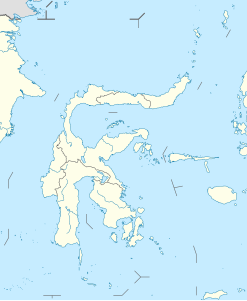
The Gulf of Bone ( Indonesian Teluk Bone ) is a large bay of the Banda Sea that divides the south of the Indonesian island of Sulawesi (formerly Celebes ) into two large peninsulas . In the east of the gulf, on the southeastern peninsula, lies the province of Sulawesi Tenggara , in the west, on the south (west) peninsula, the province of Sulawesi Selatan , which also includes the northern end of the gulf.
The gulf is named after the former sultanate of Bone on its west bank, from which the administrative district of the same name with the capital Watampone arose . Other larger cities on the Gulf are Sinjai in the south of the southern peninsula, Palopo in the northwest and Kolaka in the east of the Gulf.
According to the definition of the International Hydrographic Organization , the Gulf of Boni is a separate marine area; its border with the Banda Sea runs from Tanjung Lasa in Sulawesi Selatan to the northern tip of the island of Kabaena at 5 ° 5 ' S , 121 ° 52' E and from there northwards to the southeastern peninsula.
Individual evidence
- ^ Limits of Oceans and Seas, 3rd edition. (PDF; 994 kB) International Hydrographic Organization (1953). Retrieved February 7, 2010.
