Palopo
| Kota Palopo Palopo |
||
|---|---|---|
|
|
||
| Coordinates | 3 ° 0 ′ S , 120 ° 12 ′ E | |
| Symbols | ||
|
||
| Basic data | ||
| Country | Indonesia | |
|
Geographical unit |
Sulawesi | |
| province | Sulawesi Selatan | |
| ISO 3166-2 | ID-SN | |
| surface | 155.2 km² | |
| Residents | 120,000 | |
| density | 773.2 Ew. / km² | |
| Website | www.palopokota.go.id (Indonesian) | |
|
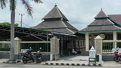
The Masjid Tua mosque from 1604
|
||
Palopo is the third largest city in Sulawesi Selatan Province in Indonesia . Until the beginning of 2006, the city, which had been an independent city since 2002, was the capital of the region ( Kabupaten ) Luwu . The port city in the northwest of the Gulf of Bone has over 120,000 inhabitants on an area of 155.19 km².
Palopo was founded around 1620. Little is known about Palopo before the Dutch annexation of South Sulawesi in 1905. The city is the site of the oldest mosque in South Sulawesi, the Jami Tua from 1604.
Web links
Commons : Palopo - collection of images, videos and audio files


