
Burgas Bay

| |
Black Sea |
Coordinates: 42 ° 30 ′ 4 ″ N , 27 ° 31 ′ 32 ″ E


The Bay of Burgas also the Gulf of Burgas ( Bulgarian Бургаски залив Burgaski zaliw ) is a larger sea bay in the western Black Sea . It has been named after the port city of Burgas since 1784 and is the largest in Bulgaria and one of the largest in the Black Sea. Other cities in the bay are Sozopol , Pomorie and Nessebar . Burgas Bay is the westernmost point of the Black Sea.
The French André-Joseph Lafitte-Clavé , who visited the western Black Sea as part of an Ottoman reform commission, described Burgas as the most important city in the bay in 1784 and was the first to name the bay under the name Bay of Burgas , with the remark that it was previously under bay from Poros was known. Occasionally after 1784 it was called the Bay of Poros or Bay of Foros , after the port of Poros / Foros (today Kraimorie , district of Burgas).
The bay narrows to the west, where it borders on the Burgasseen . The northernmost point of Burgas Bay is Cape Emine , the southernmost is Cape Maslen Nos . There are several islands in the bay. Of these, the islands of Sweti Ivan and Sweta Anastasia are the largest.
photos
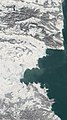
Satellite photo of the Burgas Bay

Panoramic view of the southern Sozopol Bay

The islands in the bay near Sozopol.

The western point with the Burgasseen


Individual evidence
- ↑ Michael Arnold: Antoine-Henri Jomini - the founder of scientific military theory: an assessment from the Russian perspective in strategy and conflict research , vdf Hochschulverlag AG, 2004, p. 73
- ↑ Archive link ( Memento of the original from February 13, 2006 in the Internet Archive ) Info: The archive link was inserted automatically and has not yet been checked. Please check the original and archive link according to the instructions and then remove this notice.
- ↑ See Karajotow / Rajtschewsko / Iwanow: Geschichte der Stadt Burgas (from the Bulgarian История на Бургас), 2011, ISBN 978-954-92689-1-1 , pp. 68, 274; and André-Joseph Lafitte-Clavé / M. Duverne de Presle: Reconnoissance nautique et militaire du Golfe de Bourgas, au Nord-Est de Constantinople in Annales des sciences et des arts , Volume 3, Colas, 1810, pp. 58-59
- ↑ Bourgas Bay between the coastline and the straight line joining Cape Emine and Cape Maslen Nos (PDF; 158 kB) in Maritime Space, Inland Waterways and Ports Act of the Republic of Bulgaria 28 January 2000 (1) , www.un.org