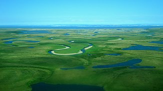
Goodhope River
| Goodhope River | ||
|
Goodhope River in the lower reaches |
||
| Data | ||
| Water code | US : 1413068 | |
| location | Alaska (USA) | |
| River system | Goodhope River | |
| Headwaters | Highlands in the north of the Seward Peninsula 65 ° 42 ′ 49 ″ N , 163 ° 23 ′ 18 ″ W |
|
| Source height | approx. 370 m | |
| muzzle |
Kotzebue-Sund ( Tschuktschensee ) Coordinates: 66 ° 4 '26 " N , 163 ° 44' 36" W 66 ° 4 '26 " N , 163 ° 44' 36" W |
|
| Mouth height | 0 m | |
| Height difference | approx. 370 m | |
| Bottom slope | approx. 3.1 ‰ | |
| length | approx. 120 km | |
| Catchment area | approx. 1250 km² | |
| Left tributaries | Placer Creek, Humboldt Creek | |
| Right tributaries | Cottonwood Creek, Eagle Creek | |
The Goodhope River is a 120 km long tributary of the Chukchi Sea in the north of the Seward Peninsula in Alaska .
The Goodhope River rises in the highlands in the north of the Seward Peninsula, 9 km northwest of Imuruk Lake , at an altitude of about 370 m . Initially it flows to the northwest. The Cottonwood River joins the river on the right, Placer Creek later on from the left. This then turns to the north and finally to the northeast. The Goodhope River meanders through the lowlands. He shows a strongly meandering behavior. The tributaries of Humboldt Creek from the left and Eagle Creek from the right meet the river. The Goodhope River finally flows into Goodhope Bay , a wide bay in the southwest of Kotzebue Sound, with three larger river arms . The course and drainage basin of the Goodhope River are within the Bering Land Bridge National Preserve . A refuge is located on the Cottonwood River, not far from its confluence with the Goodhope River. Another refuge is 25 km above the mouth on the left bank of the Goodhope River. The river drains an area of about 1250 km².
The river was named in 1901 by the US Geological Survey (USGS) after its mouth, Goodhope Bay. Their name comes from Lieutenant Otto von Kotzebue , who during his reconnaissance trip, the Rurik expedition , in August 1816, the bay reached and good hope (Engl. Good hope to make) was new geographical discoveries.
