Gorongosa (District)
| Gorongosa district | |
|---|---|
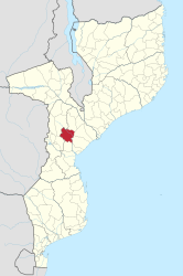
 Location of the Gorongosa district in Mozambique |
|
| Basic data | |
| Country | Mozambique |
| province | Sofala |
| surface | 6776 km² |
| Residents | 143,518 (2013) |
| density | 21 inhabitants per km² |
| ISO 3166-2 | MZ-S |
Coordinates: 18 ° 41 ′ S , 34 ° 5 ′ E
Gorongosa is a district of the Sofala Province in Mozambique with the capital Gorongosa . Its territory is bordered to the north by the Maringué district and the Manica province , to the east by the Muanza and Cheringoma districts , to the south by the Nhamatanda district and to the west by the Manica province.
geography
The Gorongosa District is 6,776 square kilometers and in 2013 had a population of 143,518 people.
Its main rivers are the Vanduzi and Chitunga in the west and the Vunduzi and Nhandu in the east. According to the classification of Köppen and Geiger , Gorongosa is in two climate zones: tropical savannah climate (Aw) and in the Gorongosa Mountains subtropical mountain climate (Cw). The average annual rainfall is 2,241 millimeters.
The district is dominated by Gorongosa National Park , which lies in the southern foothills of the East African Rift .
population
| The Gorongosa District has a population density of 21 people per square kilometer.
The population is very young, over twenty percent of the population are under five years old and over thirty percent are between five and fourteen years of age. There are above average numbers of married couples in the district:
|

|
Facilities and services
In the district there are (as of 2013) a hundred primary schools ( Primárias) , of which 75 public schools and 25 private schools. Of the eight secondary schools (Secundárias) , four are public and four are private.
There are eleven health centers and five outpatient departments in Gorongosa.
Administrative division
The Gorongosa district is divided into three administrative posts ( postos administrativos ):
Economy and Infrastructure
In 2007, two percent of the population had access to electrical energy (12.6 percent in Sofala province). Only two percent got the drinking water from a well, 44 percent from a river or pond.
Agriculture
In 2010 Gorongosa had 20,000 farms averaging 1.9 hectares of land. Most of the acreage was (as of 2000) with 12,200 hectares for maize. Cassava, beans, peanuts, millet, sugar cane and sweet potatoes were also grown.
Natural resources
Sand and gravel, graphite and gold are mined in the Gorongosa district .
traffic
The road network has a length of 146 kilometers. The national road EN1 crosses the district and runs along the western border of the Gorongosa National Park.
Gorongosa National Park
The Gorongosa National Park was founded in 1960 by the Portuguese colonial rulers. Every year 20,000 tourists visited the herds of animals with zebras, wildebeests, hippos, buffaloes, elephants and lions. During the civil war (1977–1992) rebels holed up in the woods and shot animals to eat and sell the ivory. The game population was severely depleted, of 3,000 zebras only 65 survived. Only 108 of 2,200 elephants were still alive in 1994, buffalo, wildebeest, rhinos and hippos were completely extinct.
After 2004, with the help of the American Greg Carr, the park was rebuilt and animals were introduced from the Kruger National Park . Today safaris are offered again. Warthogs, antelopes, waterbucks and hippos populate the park, there are numerous hippos and crocodiles.
Individual evidence
- ↑ a b c d e Instituto Nacional de Estatístic, Estatísticas do Distrito de Gorongosa. (PDF) November 2013, accessed May 7, 2019 (Portuguese).
- ↑ a b c d Republica de Mozambique, Perfil do Distrito do Gorongosa. (PDF) 2005, accessed May 7, 2019 (Portuguese).
- ↑ Süddeutsche Zeitung, Gorongosa National Park in Mozambique. April 13, 2014, accessed May 7, 2019 .


