
Government Center (MBTA station)
| Government Center | |
|---|---|
|
|
|
 New access structure opened in 2016 |
|
| Basic data | |
| District | Government Center |
| Opened | September 3, 1898 (Green Line) March 18, 1916 (Blue Line) |
| Tracks (platform) | 4 (2) |
| Coordinates | 42 ° 21 '34 " N , 71 ° 3' 34" W |
| use | |
| Line (s) |
_ Blue line _ Green Line |
| Passengers | 11,317 per day |
Government Center is a metro station of the Massachusetts Bay Transportation Authority (MBTA) in Boston in the state of Massachusetts of the United States . It provides access to the lines of Blue Line and Green Line and forms for this a central transfer point in the MBTA system. The connection to the Green Line took place in 1898, which makes the station the second oldest subway station still in operation in Boston.
history
On March 18, 1916, the station was connected to the Blue Line . Until the demolition of Scollay Square in 1969, which was replaced by City Hall Plaza , the station was called Scollay .
The subway station was closed on March 22, 2014 and then extensively renovated. Some of the trains on the Green Line continued to run, but passed their station without stopping. After exactly two years of construction, the underground station was reopened in March 2016.
particularities
Since there is no direct transfer option between the Blue Line and the Red Line in the MBTA network, the Government Center station is used by passengers for a different purpose, as there is a good connection to the neighboring Park Street station , where both the Green Line as well as hold the Red Line . The underground station is therefore regularly overcrowded, as Blue Line passengers who want to change to the Red Line , especially at rush hour, put additional strain on the Green Line trains between the two stations.
Railway systems
Track, signal and security systems
The subway station has a total of two central platforms and four tracks.

Green Line platform with track heading west, 2009

Track to the underground turning loop "Brattle Loop", 2011

“Brattle Loop” track and Green Line train going north after the underground station was renovated
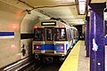
Train the Blue Line in Metro Station Government Center, 2008

Blue Line platform after renovation


,_February_2008.jpg)

building

The metro station is located at the intersection of Tremont , Dourt and Cambridge and is only partially accessible accessible.
environment
The Boston City Hall and Faneuil Hall with Quincy Market are in the immediate vicinity .
Others
In the computer game Tony Hawk's Underground 2 , the station on the Boston level is the subject of the plot.
Individual evidence
- ^ Ridership and Service Statistics. ( PDF ; 6.2 MB) Thirteenth Edition 2010. Massachusetts Bay Transportation Authority , 2010, accessed January 13, 2013 .
- ^ Jonathan Belcher: Changes to Transit Service in the MBTA district 1964-2013. ( PDF ; 911 kB) January 1, 2013, accessed on January 13, 2013 (English).
Web links
| Previous station | MBTA | Next station | ||
|---|---|---|---|---|
|
Park Street towards Boston College |
Green Line Green Line B |
final destination | ||
|
Park Street towards Cleveland Circle |
Green Line Green Line C |
Haymarket towards Boston North Station |
||
|
Park Street towards Riverside |
Green Line Green Line D |
final destination | ||
|
Park Street towards Heath Street |
Green Line Green Line E. |
Haymarket towards Lechmere |
||
|
Bowdoin terminus |
Blue line |
State towards Wonderland |
||