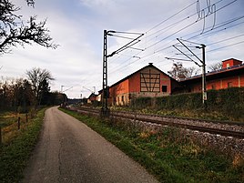
Graeffingen (Hof)
|
Graffingen
City of Boxberg
Coordinates: 49 ° 31 ′ 12 ″ N , 9 ° 35 ′ 12 ″ E
|
|
|---|---|
|
View of Graeffingen
|
Gräffingen , also called Hof Gräffingen , is a residential area in the Boxberg district of Uiffingen in the Main-Tauber district in the Franconian north-east of Baden-Württemberg .
geography
Gräffingen is located shortly after the beginning of the spring-rich Umpfertal . The development of the hamlet extends on both sides of the Umpfer with a few houses.
history
The place was first mentioned in 1245 as Greuin winds . It is a settlement of the Wends of the Franconian times, which was created from the neighboring Uiffingen . In 1390 the place consisted of only one farm. The lordship fluctuated between Boxberg and the Schüpfergrund as well as the Cent Boxberg and the Cent Königshofen . In 1610, Electoral Palatinate acquired the last quarter of the town from Eberhard von Dienheim. Since then the place has belonged entirely to the Oberamt Boxberg and, like this one, came to Leiningen in 1803 before the place became Baden in 1806.
The place came as part of the formerly independent municipality Uiffingen on January 1, 1973 to the city of Boxberg.
religion
Ecclesiastically, the place originally belonged to the parish of Uiffingen . With the Reformation, the Reformed came to Boxberg. Today the Evangelicals belong to Uiffingen again. For a long time, Catholics were legally part of Angeltürn , but were pastored from Kupprichhausen . Today the Catholics belong to Kupprichhausen.
Cultural monuments
traffic
Gräffingen is on the Frankenbahn , but without its own stop. From Uiffingen the hamlet can be reached after about two kilometers via the Gräffinger Straße of the same name , which then continues to the L 579 at Buch am Ahorn .
Web links
- Gräffingen on the website www.leo-bw.de
Individual evidence
- ↑ a b c d e LEO-BW.de: Gräffingen . Online at www.leo-bw.de. Retrieved January 13, 2020.
- ^ Federal Statistical Office (ed.): Historical municipality directory for the Federal Republic of Germany. Name, border and key number changes in municipalities, counties and administrative districts from May 27, 1970 to December 31, 1982 . W. Kohlhammer, Stuttgart / Mainz 1983, ISBN 3-17-003263-1 , p. 481 .

