Greenland (Oslo)
Coordinates: 59 ° 55 ' N , 10 ° 46' E
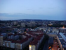
Greenland is a district area in the center of Oslo , to the east from downtown Oslo, belonging to the district Gamle Oslo . It borders Oslo's Vaterland district with the Akerselva River in the west, Tøyen and Enerhaugen in the north, as well as the old town Gamlebyen in the east and the Oslo Sentralstasjon railway line in the south (but not the train station itself). Grønland is also the name of the local main road in the area. As of January 1, 2009, Grønland had 8,321 inhabitants.
The Grønland district has a great multicultural diversity. Together with the neighboring district of Tøyen , it is a central area for immigrants and migrants in Oslo. The proportion of immigrants in Greenland is around 35–40 percent.
history

The area's coast was originally part of the outlet east of the Akerselva River . Like the North American island of Greenland , the name Grønland means grassland and is derived from the grassy bank of the Oslo area. The main street of the same name Grønland and Grønlandsleiret mark the old shoreline and are considered the historic northern border to the Bjørvika district . As Grønland has grown rapidly over the centuries, the borders of the adjacent Bjørvika have changed in favor of Grønland.
The main and most used road in the area is the Grønland road of the same name and Grønlandsleiret (formerly Leiret). It used to be the most important connection between the then suburb of Grønland and the Norwegian capital Christiania (Oslo) and led via the Vaterlands bro (Fatherland Bridge) (the first bridge was built in 1654). The former suburb of Grønland was incorporated into Christiania (now Oslo) in 1859. Many of Greenland's distinctive structures, such as the local church, Grønland kirke , school and fire station, and the nearby Botsfengselet State Prison , were all built in the 1860s.
The Grønlands Torg (Greenland Square) used to be a simple animal pen, which was used as a public cattle market and complemented with the cattle hall "Kutørjet" 1860th From 1911 to 1974 the Gartnerhallen was at the place, the cattle house and the slaughterhouse where the local slaughtering of Grønland and the Oslo area were carried out. The local meat and vegetable market was also held there. In the period from 1970 to the 1980s there was a central bus station on the square. In 1988, a new building with a central bus terminal (Oslo bussterminal) and the Galleri Oslo (Galerie Oslo), a shopping center, was built in its place and opened in 1989. The Smalgangen complex was also built on the square in the same year and was developed as a new residential and shopping center by the architects Anchor & Hølaas AS . The district in which the Oslo police headquarters are located is already affected by significant gentrification , particularly from the neighboring Bjørvika and the newly built Oslo Opera House .
traffic
Streets
The Greenland -Straße is the main street in the district, at the end point, this puts further than Grønlandsleiret continued. Then it meets the Oslo Schweigaardsgate and then continues as Oslo Gate .
Local transport
Oslo Bus Terminal ( Oslo bussterminal ) is on the westernmost tip of Greenland. There is also a bus and tram stop there. In the Grønland area, on Grønland Street, there is Grønland Stasjon underground station with a connection to the entire network of the Oslo Tunnel Railway .
Well-known structures

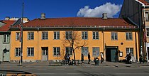
- Stepla-gården (Grønland No. 4)
- Apoteket Hjorten in Oslo (today Café and Restaurant Dattera til Hagen , Grønland No. 10)
- Goetheinstituttet (Grønland No. 16)
- Asylet ( Greenland No. 28)
- Olympen restaurant on Grønlandsleiret
- Greenland church
- Grønland brannstasjon (Grønlands fire brigade) with the historic Brannmuseet (fire brigade museum) is located.
- Botsfengselet in Åkebergveien , with Grønlands Park - Botsparken
- World Islamic Mission in Åkebergveien
- Police station of the Oslo Police District on Grønlandsleiret
- Grønlandshagen on Grønlandsleiret
Web links
- Grønland on snl.no in the store norske leksikon
- Greenland on bydel-gamle-oslo.oslo.kommune.no
- Local history page about Greenland including historical maps on home.no
- Article: «Grønland. Bydelen ingen ville ha », Aftenposten , February 8, 2010 on aftenposten.no
Individual evidence
- ^ Aftenposten.no - Moralkontroll i Oslos innvandrergater (Moralkontroll in Oslo's immigration area) on aftenposten .no, accessed on: April 8, 2013 (Norwegian)


