
Akerselva
| Akerselva | ||
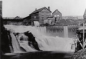
 Akerselv waterfall |
||
| Data | ||
| location | Oslo , Norway | |
| River system | Akerselva | |
| source | Outflow of the Maridalsvannet 59 ° 58 ′ 10 ″ N , 10 ° 47 ′ 16 ″ E |
|
| Source height | 149 m | |
| muzzle | In Oslo in the Oslofjord coordinates: 59 ° 54 ′ 27 " N , 10 ° 45 ′ 19" E 59 ° 54 ′ 27 " N , 10 ° 45 ′ 19" E
|
|
| length | 8.2 km | |
| Big cities | Oslo | |
The Akerselv (Norwegian: Akerselva; -a = feminine specific article) is a river in the Norwegian capital Oslo .
course
The river flows north to south through the city of Oslo. It drains the lake Maridalsvannet and flows through the districts of Nordre Aker , Sagene , Grünerløkka , Zentrum and Grønland . The mouth is on the Paulsenkaien on the Oslofjord . The entire river is about 8.2 kilometers long and has a height difference of about 149 meters. There are 23 waterfalls in the river. The last 500 or so before its mouth, the river flows in a culvert built in 1964 , parallel to the Nylandsveien road and below the tracks of the Oslo Sentralstasjon . The culvert on the Oslofjord ends directly behind the new building of the Norwegian Opera & Ballet .

Usage and history
The hydropower of Akerselva has already been used in 1220 for operating a mill. In historical maps from the period 1794 to 1795 the river is still referred to as "Agger's elv" (Agger's River ) or as "Waterland's-elv" ( Waterland River ), after the neighboring Oslo district of Vaterland . Later it was also called Vaterlandselva , especially on the west bank in the lower reaches of the river in the area of the Vaterland district. In the 18th and 19th centuries, it was used to generate energy and supply water to a number of industrial companies, including the Christiania Spigerverk steelworks , the Hjula weaving mills and some paper mills in the upper course of the river. Some shipyards settled at the estuary, including the Akers mekaniske verksted and the Nylands mekaniske verksted . The river was heavily polluted by industrial and other sewage discharges, so that among other things the native salmon disappeared and the river degenerated into a sewer. In the 1980s, a local initiative began to limit discharges.

Industry on the banks of the Akerselv
Mill for the use of water power

Factories between 1880 and 1910


Today the river is Oslo's "green lung". There are many parks and hiking trails on its banks. The existing hiking trails make it possible to hike the entire course of the river from Maridalsvannet to the fjord. Some areas through which the river flows have been declared nature reserves . Many of the historic industrial companies have given way to modern residential areas. In many places you can still see the historic factory halls, some of which are used as living space, for gastronomy, as workshops or as office buildings.
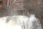
Akerselv waterfall

Park landscapes on both sides of the river

New use of the old factory halls on Akerselv


Trivia
In March 2011, around 6,000 liters of chlorine from a sewage treatment plant on the northern section of the river entered the river, which led to major fish deaths.
literature
- Gunnar Jerman: Akerselva, Fra Sagatid til Opera , Schibsted , Oslo 2003
- Tallak Moland: Historien om Akerselva gjennom de siste 400 år , Christiania forlag, Oslo 2011 ISBN 978-82-997321-1-6
- Sigurd Senje: Akerselva. Langs tjue fossefall fra Maridalen til Bjørvika , Tiden, Oslo 1977. New edition, revised by Morten Jøldal, entitled Akerselva , Topografisk Forlag, 2005. ISBN 82-7981-033-1 .
Web links
- Akerselva in the store norske leksikon (Norwegian)
Individual evidence
- ↑ Møllene Akerselvavandring.no, accessed on March 18, 2020
- ↑ Christiania by og dens marker optagne 1794 and 1795
- ↑ The Akerselva River , Visit Oslo, accessed March 7, 2020
- ↑ Klorutslipp har utradert livet i Akerselva , Aftenposten , accessed on March 14, 2020