Grünalmkogel
| Grünalmkogel | ||
|---|---|---|
|
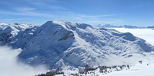
Northwest flank of the Grünalmkogel |
||
| height | 1821 m above sea level A. | |
| location | Upper Austria , Austria | |
| Mountains | Höllengebirge , Salzkammergut Mountains | |
| Dominance | 2.83 km → Vorderer Kesselgupf | |
| Notch height | 215 m ↓ Franzental | |
| Coordinates | 47 ° 48 '51 " N , 13 ° 38' 23" E | |
|
|
||
| Normal way | Hike | |
The Grünalmkogel is 1821 m above sea level. A. the highest mountain in the western Hell Mountains . The almost 500 meter high northwest flank falls down to the Pfaffengraben. The northeast face towers over the Langbathseen by more than 1000 meters. The promising summit is usually visited when crossing the Höllengebirge.
Climbs
- From the Hochleckenhaus on the marked path 820 over the plateau, walking time: around 2.5 to 3 hours
- From the Rieder Hütte on the marked path 820 over the plateau, walking time: around 2.5 to 3 hours
Individual evidence
- ^ Franz Hauzenberger: Höllengebirge. Hiking, climbing and ski guides . 2nd edition, self-published, Vöcklabruck 2005

