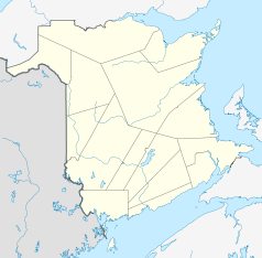
Grand Falls, New Brunswick
| Grand Falls | ||
|---|---|---|
| Location in New Brunswick | ||
|
|
||
| State : |
|
|
| Province : | New Brunswick | |
| County: | Victoria County | |
| Coordinates : | 47 ° 3 ′ N , 67 ° 44 ′ W | |
| Height : | 160 m | |
| Area : | 18.06 km² | |
| Residents : | 5595 (as of 2011) | |
| Population density : | 309.8 inhabitants / km² | |
| Time zone : | Atlantic Time ( UTC − 4 ) | |
| Municipality number: | 506 | |
| Postal code : | E3Z 1G6 | |
| Mayor : | Richard Keeley | |
| Website : | www.grandfallsnb.com | |
Grand Falls (French: Grand-Sault ) is a city in Victoria County in the Canadian province of New Brunswick with 5595 inhabitants (2011), who mostly speak French .
geography
Grand Falls is bounded by New Brunswick Route 2 to the west and the connecting roads New Brunswick Route 105 and New Brunswick Route 108 to the east. Edmundston is 34 miles to the northwest. The Saint John River flows through the village . The border with the US state of Maine is only four kilometers to the west from the city center.
history
Acadians , Francophone Canadians and British settlers all settled in the area on the banks of the Saint John River in the 19th century . The name used there by the indigenous population was Chicanekapeag (great destroyer) and referred to the sometimes destructive power of the river. The current name Grand Falls means "Great Waterfall" and is derived from the fact that the water of the Saint John River falls around 23 meters at this point. NB Power, responsible for the province of New Brunswick, took advantage of this by building a 66 MW hydroelectric power station in 1959 to generate electricity.
gallery
sons and daughters of the town
- Patrick Côté (* 1985), biathlete
- Gerry Ouellette (* 1938), ice hockey player
Individual evidence
Web links
- Grand Falls Gorge - waterfall


