Grande Terre (New Caledonia)
| Grande Terre | ||
|---|---|---|
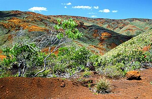
| Landscape in the south | ||
| Waters | Coral sea | |
| Archipelago | New Caledonia | |
| Geographical location | 21 ° 17 ′ S , 165 ° 21 ′ E | |
|
|
||
| length | 400 km | |
| width | 60 km | |
| surface | 16,664 km² | |
| Highest elevation |
Mont Panié 1628 m |
|
| main place | Nouméa | |
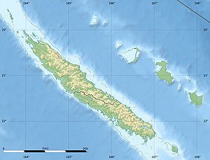
| Topographic map | ||
The island of Grande Terre is the main island and by far the largest island in New Caledonia , it is located in the Coral Sea .
geography
Grande Terre has an area of 16,664 km². It is approx. 400 km long and 50 to 60 km wide. The island is traversed by a mountain range of folds with a total of four mountain peaks that exceed 1500 m. At 1628 m, Mont Panié is the highest and Mont Humboldt at 1618 m is the second highest. Around the island lies the New Caledonian Barrier Reef . The longest river on the island is the 150 km long Diahot , the largest city, the capital of New Caledonia, Nouméa .
The mountains represent a climatic divide. The west lies in the slipstream of the trade winds and is therefore relatively dry, with savannah and bush landscapes. The east receives significantly more precipitation; in many places the vegetation is characterized by tropical forests.
The island was once part of the eastern edge of Gondwana . It separated from the Australian continent 80 million years ago and from New Zealand 55 million years ago and migrated to the northeast. Today Grande Terre lies on the edge of the Australian lithospheric plate , which dips under the Pacific lithospheric plate ( plate tectonics ). One consequence of this is that the seabed, together with the island of Grande Terre and other islands, such as the Belep Islands and the Atoll de la Surprise in the northwest and the Île des Pins , the Île Ouen and the Île Koutoumo in the southeast, is slightly raised has been. The Loyalty Islands to the east are even of volcanic origin, as they are even closer to the plate edge.
Web links
- croixdusud.info: New Caledonian archipelagos
Individual evidence
- ↑ Marianne Weissbach, Michael Brillat: Nelles Guide Travel Guide South Seas: Solomon Islands, Vanuatu, New Caledonia, Fiji Islands, Samoa, Tonga, Cook Islands, Polynesia, Easter Island. Nelles Verlag, 2017, ISBN 978-3-86574738-9 , pp. 77f.


