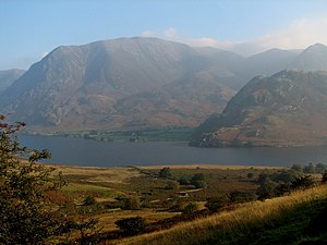
Grasmoor (mountain)
| Grass moor | ||
|---|---|---|
|
The Grasmoor over Crummock Water seen |
||
| height | 852 m ASL | |
| location | Cumbria , England | |
| Mountains | Cumbrian Mountains | |
| Coordinates | 54 ° 34 ′ 18 ″ N , 3 ° 16 ′ 41 ″ W | |
|
|
||
| Type | Wainwright , Marilyn (Mountain) | |
The Grasmoor is a mountain in the Lake District , Cumbria , England . The Grasmoor is one of the 214 mountains of the Lake District described by Alfred Wainwright . The Grasmoor is 852 m high and has a notch height of 519 m.
The Grasmoor is north of Buttermere and drops to the west directly into Crummock Water , from where there is a direct ascent option.
swell
Alfred Wainwright, Pictorial Guide to the Lakeland Fells, Vol. 6 The North Western Fells , Frances Lincoln, 2004, ISBN 978-0711224599

