
Grazbach (Mur)
| Grazbach | ||
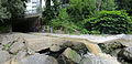
 Grazbach shortly before the confluence with the Mur , seen upstream |
||
| Data | ||
| location | Graz , Styria , Austria | |
| River system | Danube | |
| Drain over | Mur → Drava → Danube → Black Sea | |
| origin | The confluence of the Kroisbach and Leonhardbach rivers at the Mandellstrasse intersection. - Sparbersbachgasse 47 ° 4 ′ 2 ″ N , 15 ° 27 ′ 0 ″ E |
|
| muzzle | on the northern edge of the Augarten, at the Augarten Bridge, in the Mur Coordinates: 47 ° 3 '50 " N , 15 ° 26' 5" E 47 ° 3 '50 " N , 15 ° 26' 5" E |
|
| Mouth height |
340 m above sea level A.
|
|
| length | 1.3 km | |
| Catchment area | 46.11 km² | |
The Grazbach is an underground city stream in Graz .
It is created by the confluence of the Kroisbach and Leonhardbach rivers . At the intersection of Mandellstrasse and Sparbersbachgasse in the St. Leonhard district , both streams flow underground to form the Grazbach. Its course follows parts of Sparbersbachgasse , Dietrichsteinplatz and Grazbachgasse .
history
Until the 19th century the Grazbach flowed through the Graz suburbs in the east of the city and flowed into the Mur on the terrain of today's Augartenbad . Since the stream was used for sewage disposal, but kept drying out in summer, the decision was made around 1879 to straighten and build over the stream.
The construction work was carried out in two stages. The lower course was built over between 1880 and 1883, the upper course between 1885 and 1887. In the course of the straightening, the mouth was moved from the south of the Augarten (near Augartenbad) to the northern edge of the park.
Trivia
From 2005 took place a few years, at least until 2011, long on the water day Grazer water channel running instead. This led from the banks of the Mur partly through the Grazbach canal and a staircase or ladder back to the road surface.
Mixing with wastewater in the event of heavy rain
On the map of the waters (and canals) of Graz, one single route stands out as three-way. Over a length of more than 1 km and a route that has been slightly bent several times, three channels run here at a constant distance. At least in the area of Grazbachgasse, the built-up cross-section of the Grazbach Canal consists of a single lumen, but of three parallel channels. In the middle is the wider channel of the relatively clean Grazbach with a deeper bottom. To the left and right of it run the collecting channels for dirtier mixed water from the sewer system on both sides of the stream.
For most of the year, the three water streams run separately and the walkways between them can be walked dry. Entrance is (as of October 2017, before the erection of site fences for the central storage channel) from the outlet opening on the Mur, even if a notice prohibits unauthorized access. The only always open exit - via a ladder - is at the non-built-up area north of the Sacred Heart Church , an intermediate exit (as of June 2019, however, locked from the canal) via a staircase and an iron cover that can be folded up is located on a house front the southeast side of Sparbersbachgasse, a few meters east of the confluence with Schörgelgasse.
When there is little water in the sewer system, the incoming Grazbach creek and the water level of the Mur is not too high, the three channels flow hydraulically separated and both wastewater flows sink shortly before reaching the sewer opening on the embankment of the Mur into the lower crossing left mud-accompanying collecting channel leading to the Gössendorf sewage treatment plant leads.
Particularly in the event of heavy rain in the catchment area of the sewers concerned, their water flow increases so much that a mixture of wastewater and rainwater from wastewater channels reaches the central channel of the brook. A mixture can also occur through flooding from the Grazbach. In both cases, for a few hours on a few days of the year, untreated mixed water flows into the Mur, which as a rule also carries a lot of water during this time, making it easier to cope with.
Construction of Mur power station and storage channel
With the traffic jam after construction (beginning of autumn 2017) of the Mur power plant Puntigam , the self-cleaning power of the Mur will decrease due to the reduced flow velocity in this area, which is why the power plant was only approved under the condition of the construction of a storage channel that can store and absorb a large part of the heavy water events. The citizens' initiative “ Rettet die Mur ” and Werner Kogler from the Greens criticize the financing of the canal by the city of Graz as cross-financing of the unprofitable river power station.
photos
Grazbach estuary, concreted and with granite paving (2015)
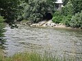
Grazbach estuary, seen from the opposite bank of the Mur

Grazbach, already without wastewater channels, just before the mouth


Individual evidence
- ↑ Extract from the digital Styrian body of water index. State of Styria , accessed on February 2, 2017 .
- ↑ BMLFUW (ed.) : List of areas of the Austrian river basins: Mur area. In: Contributions to Austria's Hydrography Issue No. 60, Vienna 2011, p. 76.
- ↑ The Grazbach came underground austria-forum.org
- ↑ Watercourse 2009 ( Memento of the original from December 1, 2015 in the Internet Archive ) Info: The archive link was automatically inserted and not yet checked. Please check the original and archive link according to the instructions and then remove this notice. wasserland.steiermark.at (PDF; 1.5 MB)