Great Divide Basin
The Great Divide Basin (in German roughly basin of the great watershed ) is an area with no drainage in the southwest of the US state Wyoming . In a sense, it represents an "island" in the course of the continental divide of North America .
location
The Great Divide Basin is located in the southwest of the state of Wyoming, immediately south of the South Pass , where the great continental divide divides into two branches: one runs south and another east. Both branches enclose the roughly oval-shaped area, which has an area of approximately 10,000 km². It is a little bigger than the island of Cyprus.
nature
As a run-off ( endorheic ) plateau in the middle of the Rocky Mountains , the basin is a very dry, barren area. Its landscape is characterized by deserts and semi-deserts , salt plains and sparse grasslands. Since it is largely uninhabited (the only town in the area is Wamsutter ), it is a very unspoilt region. Here come pronghorn , mule deer , Mustangs and occasionally moose before.
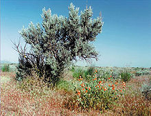
The area has no closed forests. There are only grasslands and bushes, especially the sagebrush , which is well adapted to the drought and which is an important source of food for the ungulates mentioned. In some bare places bizarre rock formations come to light.
Natural resources
Deposits of oil , natural gas and uranium have been discovered in the area of the basin . Exploitation is countered by considerations to designate the area as a national monument or wilderness area .
Despite this, more and more natural gas reserves have been drilled in recent years and companies such as BP and Halliburton are now involved in the exploitation of the oil reserves. The population of Wamsutter, which functions as the center of local gas production, is therefore increasing steadily.
According to information from BP, a total of 950 wells were in operation in the Wamsutter area in early 2007. The value of the gas reserves is estimated at US $ 2.2 billion. Since the reserves are considered difficult to develop, particularly modern drilling techniques are being tested in the gas fields.
Almost the entire area of the basin is owned by the federal government and is administered by the Bureau of Land Management , an agency of the Interior Ministry.
traffic
Although almost completely unpopulated, the basin is traversed by two highways : Interstate 80 runs from the east coast to San Francisco in an east-west direction, and US-287 runs from Montana to Texas in a north-south direction . In addition, the transcontinental railway line of the Union Pacific Railroad, opened in 1869, runs through the basin.
Large pool
The name "Great Divide Basin" can be confused with the name "Great Basin". "Great Basin" ( " Great Basin "), however, referred to another, much larger outflow-free area in the western US, the west of the Continental Divide is located. In contrast to the Great Divide Basin, the Great Basin is definitely inhabited. Here are u. a. the Great Salt Lake and the City of Salt Lake City .
Literature and Sources
- Bryce S. Walker: The Rocky Mountains. 10. German print. Time-Life Books, Amsterdam 1990, ISBN 90-6182-067-7 ( The wilds of the world ).
- ↑ Marc Pitzke: Raw material boom: Reibach in the Rockies. In: Spiegel Online . October 14, 2005, accessed June 10, 2018 .
- ↑ http://www.deutschebp.de/liveassets/bp_internet/germany/STAGING/home_assets/assets/deutsche_bp/pressemeldung_2005/220107_pm_oman_gasfund.pdf
- ↑ http://www.bp.com/liveassets/bp_internet/globalbp/STAGING/global_assets/downloads/G/2005_SR_German_language_accessiable.pdf
Web links
Coordinates: 42 ° 5 '34.8 " N , 108 ° 21' 39.1" W.


