Greater Taree City
| City of Greater Taree | |
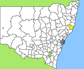
 Location of Greater Taree City in New South Wales |
|
| structure | |
| State : |
|
| State : |
|
| Administrative headquarters: | Taree |
| Dates and numbers | |
| Area : | 3,730 km² |
| Residents : | 46,541 (2011) |
| Population density : | 12 inhabitants per km² |
Coordinates: 31 ° 54 ′ S , 152 ° 27 ′ E The City of Greater Taree was a local government area (LGA) in the Australian state of New South Wales . The area was 3,730 km² and last had about 46,500 inhabitants. In 2016, the Mid-Coast Council made a difference.
Greater Taree was on the Pacific coast about 310 km northeast of the metropolis of Sydney and 630 km south of Brisbane . The area comprised 148 hamlets and villages, including Bobin, Caparra, Cedar Party Creek, Coopernook, Cundletown, Croki, Crowdy Head, Dyers Crossing, Glenwarrin, Hallidays Point, Hannam Vale, Harrington, Johns River, Killabakh, Kimbriki, Kolodong, Koorainghat, Krambach, Langley Vale, Lansdowne, Central Lansdowne, Manning Point, Marlee, Moorland, Mount George, Number One, Old Bar, Possum Brush, Purfleet, Stewarts River, Taree, Tinonee, Wherrol Flat, Wallabi Point, Wingham and parts of Elands and Nabiac. The seat of the City Council was in Taree in the east of the LGA, where about 18,000 inhabitants live.
administration
The Greater Taree City Council had twelve members, eleven councilors, and the chairman and mayor were elected by the residents of the LGA. Greater Taree was not subdivided into districts.
Personalities
- Troy Bayliss , motorcycle racer
- John Coates , mathematician
Web links
- Official site of the Greater Taree City Council
- Hunter Councils: Greater Taree (C) Community Profile ( August 31, 2007 memento in the Internet Archive )
- id.com.au: Greater Taree City Community Profile
Individual evidence
- ↑ a b Australian Bureau of Statistics : Greater Taree (C) ( English ) In: 2011 Census QuickStats . March 28, 2013. Retrieved April 12, 2014.
- ↑ Australian Bureau of Statistics : Taree ( English ) In: 2016 Census QuickStats . June 27, 2017. Retrieved May 3, 2020.