Green Island (Antarctica)
| Green Island | ||
|---|---|---|
| Waters | Grandidier Channel , Southern Ocean | |
| Archipelago | Berthelot Islands | |
| Geographical location | 65 ° 19 '34 " S , 64 ° 8' 58" W | |
|
|
||
| length | 520 m | |
| width | 500 m | |
| surface | 20 ha | |
| Highest elevation | 83 m | |
| Residents | uninhabited | |
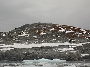
Green Iceland ( Green Island ) is the northernmost of the Berthelot Islands at the northern exit of the Grandidier Channel .
The island is about three kilometers off the Graham coast of the Antarctic Peninsula . It is 520 m long, 500 m wide and reaches a height of 83 m. The terrain is mostly steep with high cliffs in the south and east, only in the northern part of Green Island there is a gently sloping terrace . The south-eastern part of the island is glaciated, and permanent snow surfaces can also be found in the north. On the northern slope of the summit, an approximately 0.5 hectare carpet of moss spreads out, which gave the island its name. To preserve it, Green Island is designated as a specially protected area of the Antarctic (ASPA 108) according to Annex V of the Environmental Protection Protocol to the Antarctic Treaty .
Flora and fauna
A 140 m wide mat of stiff-leaved woman's hair ( Polytrichum strictum ) extends on the northern slope of the island at heights between 25 and 70 m. The peat layer is up to two meters thick and is constantly frozen from a depth of 30 cm ( permafrost ). The moss Chorisodontium aciphyllum also grows on the edge of the mat . Other mosses and lichens grow in smaller stocks on the island. The green alga Prasiola crispa is common in damp places . The only seed plant represented here is the Antarctic Schmiele ( Deschampsia antarctica ).
A breeding colony of the blue-eyed shag is located on the steep and rocky northwest flank of the island. Antarctic skuas and sub- Antarctic skuas breed in smaller numbers on Green Island.
history
Jean-Baptiste Charcot discovered the island on his first Antarctic expedition 1903-1905. On his second Antarctic expedition he visited her several times in the winter of 1909. The British Graham Land Expedition , led by John Rymill , made a rough survey of the island in 1935 and gave it its current name.
literature
- Secretariat of the Antarctic Treaty: Green Island, Berthelot Islands, Antarctic Peninsula (PDF; 3.35 MB), Management Plan for Antarctic Specially Protected Area No. 108, 2013 (English)
Web links
- Green Iceland in the Geographic Names Information System of the United States Geological Survey (English)

