Green Islands
| Green Islands | ||
|---|---|---|
| Satellite image of the Green Islands with Pinipel (above) and Nissan (below) | ||
| Waters | Pacific Ocean | |
| Geographical location | 4 ° 30 ′ S , 154 ° 10 ′ E | |
|
|
||
| Number of islands | 2 atolls with 8 islands | |
| Main island | Nissan | |
| Total land area | approx. 45 km² | |
| Residents | 5725 (2000) | |
| Administrative affiliation | ||
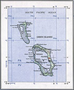
The Green Islands ( German Green Islands , originally Sir Charles Hardy Islands ) are a group of two atolls in the central Pacific Ocean . Politically, the two atolls belong to the autonomous region of Bougainville in the island state of Papua New Guinea , where they form the LLG ( Local Level Government ) Nissan.
geography
The atolls are geographically located between the Bismarck Archipelago in the northwest and the Solomon Islands in the southeast. The distance to the island of New Ireland in the west is 110 km, to the Feni Islands in the north-west 58 km and to the Bougainville offshore island of Buka in the south-east 63 km. The Green Islands consist of the smaller atoll Pinipel in the northwest and the larger atoll Nissan in the southeast, which are only two kilometers apart. The total land area is around 45 km², the main island is Nissan in the atoll of the same name. The Green Islands have a total of 5725 inhabitants (2000 census), of which 4824 live on Nissan and 901 on Pinipel.
Geologically speaking, the atolls of Nissan and Pinipel are the parts of the same seamount that rise above sea level . So they form a double atoll.
Web links
- The Green Islands on Oceandots ( Memento from December 23, 2010 in the Internet Archive )
- About the conquest of the Green Islands in the Pacific War (English)
Individual evidence
- ↑ German Colonial Lexicon. Edited by Heinrich Schnee. - Leipzig: Quelle & Meyer 1920. - 3 vols.
- ^ Gordon L. Rottman : World War 2 Pacific Island Guide , Westport, Greenwood Publishing 2002, p. 175.
- ↑ Papua New Guinea - People Land and Environment (PDF, 10.46 MB; English)


