Greers Ferry Dam
| Greers Ferry Dam | ||
|---|---|---|
| location | ||
|
|
||
| Coordinates | 35 ° 31 '15 " N , 91 ° 59' 36" W | |
| country |
|
|
| place | Cleburne County , Arkansas | |
| Waters | Little Red River | |
| Height upstream | 140.8 m | |
| power plant | ||
| owner | United States Army Corps of Engineers (USACE) | |
| operator | USACE | |
| construction time | 1959 to 1964 | |
| Start of operation | 1964 | |
| technology | ||
| Bottleneck performance | 96 megawatts | |
| Standard work capacity | 189 million kWh / year | |
| Turbines | Francis turbines : 2 × 48 MW | |
| Others | ||
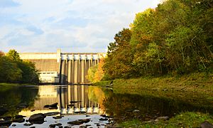
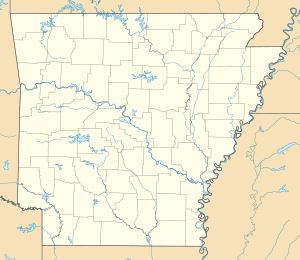
The dam Greers Ferry ( english Greers Ferry Dam ) is a dam with hydroelectric plant in Cleburne County , State of Arkansas , USA . It dams the Little Red River to a reservoir (English Greers Ferry Lake ). The small town of Heber Springs is about 5 km (3 miles ) southwest of the dam.
In addition to generating electricity, the dam is also used for flood protection and drinking water supply. Construction of the dam began in March 1959. It was completed in December 1962. The dam was inaugurated on October 3, 1963 by President John F. Kennedy . It is owned by the United States Army Corps of Engineers (USACE) and is also operated by the USACE.
Barrier structure
The shut-off is a gravity dam of concrete with a height of 74 m (243 ft ) above the river bed. The length of the top of the wall is 519 m (1704 ft). The thickness of the dam is 61 m (200 ft) at the base.
The dam wall has a flood relief with six weir fields. The maximum amount of water that was diverted via the flood relief and the turbines was 301 m³ / s (10,624 cft / s) on December 6, 2009 .
Reservoir
At the normal storage target of 140.8 m (462 ft) above sea level , the reservoir extends over an area of around 127.5 km² (31,500 acres ) and has a capacity of 3.45 billion m³ (2.8 million acre feet ) Water. The maximum storage target during high tide is 148 m (487 ft); the minimum congestion target for electricity generation is 132.6 m (435 ft). The reservoir has a length of approx. 80 km (50 miles).
power plant
The power plant is located at the foot of the dam. It was completed in July 1964. The installed capacity is 96 MW ; the power plant's two Francis turbines each have a maximum output of 48 MW. The average annual production is 189 million kWh . The flow rate is 85 m³ / s (3000 cft / s).
Others
The total cost of the project is given as $ 46.5 million .
See also
Web links
- Welcome to Greers Ferry Lake. United States Army Corps of Engineers (USACE), accessed February 2, 2019 .
Individual evidence
- ↑ a b c d Overview. United States Army Corps of Engineers (USACE), accessed February 2, 2019 .
- ↑ a b c d e Greers Ferry Dam 50th Anniversary Dedication Celebration Ceremony. (PDF) USACE, October 3, 2013, p. 2 , accessed on February 2, 2019 (English).
- ↑ a b c Greers Ferry Dam and Lake. www.encyclopediaofarkansas.net, accessed February 2, 2019 .
- ↑ Dam Facts. USACE, accessed February 2, 2019 .
- ^ A b c Greers Ferry Lake - Elevation Fact Sheet. USACE, accessed February 2, 2019 .
- ^ Greers Ferry Dam. (PDF) www.encyclopediaofarkansas.net, October 3, 1963, p. 2 , accessed on February 2, 2019 (English).

