
Border between Botswana and Namibia
.png)
The border between the Republic of Botswana and the Republic of Namibia is 1,544 kilometers long and runs in a continuous section from 24 ° 44 ′ 41 ″ S, 20 ° 0 ′ 0 ″ E in the south to 17 ° 47 ′ 25 ″ S, 25 ° 15 40 ′ E to the northeast.
Borderline
![]() Map with all coordinates: OSM | WikiMap
Map with all coordinates: OSM | WikiMap
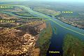
The border between Botswana and Namibia runs from a point at Nossob in the south in accordance with Article III of the Treaty between the German Empire and the United Kingdom on the colonies and Heligoland from July 1, 1890, initially northwards at 20 degrees east longitude to the 22nd south Latitude ( 22 ° 0 ′ 0 ″ S, 20 ° 0 ′ 0 ″ E), before continuing north to 21 degrees east longitude ( 22 ° 0 ′ 0 ″ S, 21 ° 0 ′ 0 ″ E to 18 ° 19 ′ 3 ″ S, 21 ° 0 ′ 0 ″ E ). To the east, the border is in an almost straight line at the Caprivi Strip until reaching the Linyanti . The border then follows the natural course of the river (later Chobe ) until it almost forms a quadrangle between Botswana, Namibia, Zambia and Zimbabwe at the end of the tip .
Border crossings
Botswana and Namibia have five (as of 2018) border crossings on their common border.
gallery
Meeting of four states

.jpg)
.jpg)
Individual evidence
- ↑ Namibia. World Fact Book. Retrieved September 17, 2018.
