Gros Islet
| Gros Islet Gros Islet |
||
|---|---|---|
|
|
||
| Coordinates | 14 ° 5 ′ N , 60 ° 57 ′ W | |
| Basic data | ||
| Country | St. Lucia | |
| Gros Islet | ||
| ISO 3166-2 | LC-06 | |
| height | 2 m | |
| Residents | 19,000 (2001) | |
| founding | 1749 | |
|
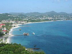
View from the height of Pigeon Island
|
||
Gros Islet (from French : Big Island ) is a place in the north of the island state of St. Lucia . He is eponymous for the Quarter Gros Islet . Originally a quiet fishing village, it has become one of the most popular tourist destinations in St. Lucia.
geography
The settlement of Gros Islet with the districts Edge Water , Bella Rosa , Beausejour Phase 1 and Bonneterre is located in the north-west of St. Lucia, south of the Cap Estates . The settlement is located on a narrow part of the island between Rodney Bay in the west and Epouge Bay in the east. Rodney Bay stretches between Mount Pimard and Pigeon Island and gives Rodney Bay in the south its name. The newer building areas (Beausejour) are only about 500 m from the east coast. Gros Islet gained access to the islet of Pigeon Island in the west through artificial filling in the 1970s, and a mangrove swamp formerly extended to the south and east, which was dug to create the Rodney Bay Marina. To the southeast, Mont Layou (Monchy) limits the settlement area. The Darren Sammy National Cricket Stadium is also on this border .
history
Originally there were Carib settlements in the area . A French map from 1717 lists the area for the first time as "Gros Islet". The first colonial settlers were French from Martinique . The first Catholic priests on the island settled in the place in 1749, so it is one of the oldest Catholic parishes .
In 1778 the British captured the island in retaliation for the French declaration of war and established a naval base in Gros Islet Bay (1782), changing the name temporarily to Fort Rodney . The island was to change hands several times between the British and the French.
The church has flourished recently. Between 1991 and 2001 the population grew by 54%; the highest increase in the country. In 2001, 19,409 inhabitants were recorded, making it the second largest municipality in St. Lucia (13,505 in 1991 and 10,164 in 1980).
Buildings
Individual evidence
- ^ The Beach at Rodney Bay Caribya.
- ↑ geonames.org .
- ↑ Originally: Beausejour Cricket Ground , renamed after Darren Sammy in 2016 . List of international cricket centuries at the Darren Sammy National Cricket Stadium
- ↑ K. Luntta: The Rough Guide to St Lucia : 82.
- ↑ Gros Islet Parish history ( Memento of the original from July 26, 2011 in the Internet Archive ) Info: The archive link was automatically inserted and not yet checked. Please check the original and archive link according to the instructions and then remove this notice.
- ↑ a b 2001 Population and Housing Census ( Memento of the original from March 25, 2009 in the Internet Archive ) Info: The archive link was inserted automatically and has not yet been checked. Please check the original and archive link according to the instructions and then remove this notice.

