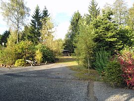
Gertrudensegen Pit
| Gertrudensegen Pit | |||
|---|---|---|---|
| General information about the mine | |||
| Site of the former Gertrudensegen mine | |||
| Information about the mining company | |||
| Start of operation | 1855 | ||
| End of operation | 1966 | ||
| Funded raw materials | |||
| Degradation of | Zinc blende , lead luster , copper , siderite | ||
| Geographical location | |||
| Coordinates | 50 ° 53 '17 " N , 7 ° 21' 34.6" E | ||
|
|||
| Location | Pillenhof | ||
| local community | Much | ||
| District ( NUTS3 ) | Rhein-Sieg district | ||
| country | State of North Rhine-Westphalia | ||
| Country | Germany | ||
| District | Bensberg ore district | ||
The Gertrudensegen mine is a former non-ferrous metal ore mine in the Bensberg ore district . It was between Pillenhof and Markelsbach in the municipality of Much in the Rhein-Sieg district .
history
The Gertrudensegen mine owes its name to the innkeeper 's daughter Gertrud Haas from Markelsbach, who discovered this mine in 1842. It is not known whether the work had already started at this point in time. The first assumption comes from Justus Bleibtreu from Ramersdorf on November 27, 1855 . The award followed on June 27, 1857 for zinc, lead, copper and iron. The mine soon became the property of the Gertrudensegen trade union , whose representative was Gustav Roetzel . He applied for an expansion of the pit on January 8, 1866 and received the award on June 9, 1868. In 1878, operations were stopped. In 1935 it was reopened as a consolidated Nikolaus-Phönix mine, together with the Emanuel and Antonius mine .
Operation and facilities
From a report of Representatives Roetzel from 1878 show that the lead and Zinkerzgang m over a length of 400 open-minded and was known m on a further length of 440th Near Pillenhof had a tunnel driven forward while noble siderite found. Despite good predictions about sufficient stocks, the company closed the same year because the ore prices were too low and at the same time the transport and operating costs became more expensive. 97 miners lost their jobs.
The extraction shaft stood on the site of the summer houses agriculture. A small memorial stone, which is now covered with agricultural goods, is intended to remind of the shaft with the following inscription:
“Gertrudensegen mine, main shaft; Cross section: 2.40 X 1.60 mtr .; Distance: 2.00 Mtr. N. Filled: 25.10.66 "
From here the company buildings and dumps extended towards the Pillenhof. There was another shaft about 100 m before the confluence of the road from Niederheimbach to Zeithstraße.
Individual evidence
- ^ A b Günter Benz: Mining in the community of Much , second revised edition, Bruchhausen 2014, p. 228ff.
literature
- Claudia Maria Arndt (ed.): Von Wasserkunst and Pingen, ore mining in the Rhein-Sieg district, Rheinlandia Verlag, Siegburg 2005, ISBN 3-935005-95-4
Web links
- Günter Benz: Mining An almost forgotten branch of industry in the municipality of Much, accessed on September 30, 2016

