Bottomless lake (Upper Bavaria)
| Bottomless lake | ||
|---|---|---|

|
||
| Bottomless lake from the jetty on the east bank | ||
| Geographical location | District of Rosenheim , Bavaria | |
| Drain | Lienzinger Bach → Söller Bach → Chiemsee | |
| Data | ||
| Coordinates | 47 ° 54 '54 " N , 12 ° 25' 5" E | |
|
|
||
| Altitude above sea level | 538 m | |
| surface | 0.3 ha | |
| length | 100 m | |
| width | 56 m | |
| scope | 280 m | |

|
||
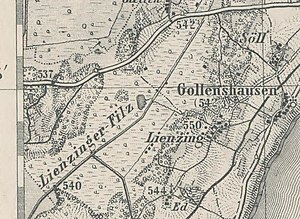
| Map from 1893, with the Grundlose See at the end of the name Lienzinger Filz | ||
The Grundlose See is a moor lake only 0.3 hectare in size in the center of the Lienzinger Filz high moor , 640 meters west-northwest of the hamlet of Lienzing in the municipality of Gstadt am Chiemsee . It is located 1300 meters west-northwest of the western Chiemsee shore of Gollenshausen am Chiemsee and around 20 meters higher than the Chiemsee. The lake measures almost 100 meters from north to south and is up to 56 meters wide. It was created as a dead ice hole . In its silting area, the lake has tread-sensitive vibrating lawns .
The small lake drains eastwards via the Lienzinger Bach ( called Filzmoosgraben on the map ) and the Söller Bach north of Gollenshausen into the Chiemsee, near the hamlet of Lambach, which already belongs to the neighboring community of Seeon-Seebruck . The Söller Bach is named after the hamlet of Söll (immediately north of Gollenshausen).
The Lienzinger Filz is a biotope-mapped moor and part of the biotope network axis between Eggstätt-Hemhofer Seenplatte and the Seeoner Lakes .
Individual evidence
- ↑ Hiking in the western Chiemgau, Tour 3, p. 18 (PDF; 5 MB)
- ↑ Lienzinger Filz information board (PDF; 1.8 MB)
- ↑ Biotope network Eggstätt Hemhofener Seenplatte and Seeoner Seen (PDF; 4.7 MB)
