Gurué
| Gurué | ||
|---|---|---|
|
|
||
| Coordinates | 15 ° 28 ′ S , 36 ° 59 ′ E | |
| Basic data | ||
| Country | Mozambique | |
| Zambezia | ||
| ISO 3166-2 | MZ-Q | |
|
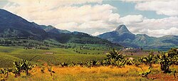
The Manuel Saraiva Junqueiro tea plantation with Monte Murresse in the background
|
||
Gurué ( Gurúè ) is a city in Mozambique in the province of Zambezia . Until the independence of Mozambique in 1975 the place was called Vila Junqueiro . "Gurué" is said to be the name of the local Lomwe for the peccary .
geography
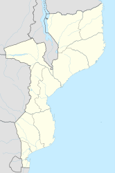
Since 1998 Gurué is a municipality with an area of 107 km². Gurué is 350 km away from the provincial capital Quelimane , Nampula and the Malawian Blantyre . The area north of the city is forested and mountainous. Here you will find zoological rarities, such as the endemic Namuli fine singer . At 2419 m , Monte Namuli is the highest mountain in the province.
population
Gurué has 127,074 inhabitants (2009). In 1997 it was 99,325.
The place is the seat of the diocese Gurué .
history
The place was founded in the 19th century by the Portuguese . They built tea plantations in the area. Living conditions deteriorated during the Mozambican Civil War (1977-1992). The place suffered from the departure of the retornadoes , the white Portuguese, and natural disasters occurred.
economy
90 percent of the income comes from the cultivation and processing of tea. The largest cultivation area in the country is located here. The rest of the income comes from growing fruits, coconut trees and coffee.
Culture
The award-winning film Tabu - A Tale of Love and Guilt by Portuguese director Miguel Gomes was shot here in 2012.
Web links
- Video from before 1975 about the provincial capital Quelimane and tea cultivation in Gurué (Portuguese)

