Höllrich
|
Höllrich
community Karsbach
Coordinates: 50 ° 4 ′ 0 ″ N , 9 ° 47 ′ 39 ″ E
|
|
|---|---|
| Height : | 237 m above sea level NHN |
| Residents : | 431 (Jan. 9, 2017) |
| Incorporation : | May 1, 1978 |
| Postal code : | 97783 |
| Area code : | 09358 |
|
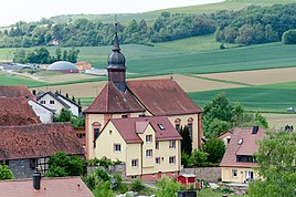
Ev. Parish church in Höllrich
|
|
Höllrich is a district of Karsbach in the Main-Spessart district in Bavaria .
geography
The village is located at 237 m above sea level. NHN on federal road 27 between Weyersfeld and Heßdorf . To the west is the village of Seifriedsburg , which belongs to Gemünden am Main , and to the east is the Hammelburg military training area . The Kuhbach (formerly Karsbach) flows through Höllrich . In the stands Höllrich Castle and the Protestant village church .
history
Höllrich is first mentioned in a document in 1189 as Holderich .
Web links
- Höllrich district , on the website of the Gmünden administrative association
Individual evidence
- ↑ Contour lines on the BayernAtlas of the Bavarian State Government ( notes ).
- ↑ Höllrich district , on the website of the Gmünden administrative association
