Hünenburg (Bomlitz)
| Hünenburg | ||
|---|---|---|
|
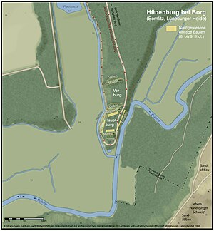
Traces of terrain and proven buildings of the Hünenburg |
||
| Creation time : | 8th to 9th centuries | |
| Castle type : | Höhenburg, spur location | |
| Conservation status: | Burgstall | |
| Standing position : | Nobles | |
| Construction: | Back-filled double palisades | |
| Place: | Walsrode - Borg | |
| Geographical location | 52 ° 52 '49.7 " N , 9 ° 37' 35.2" E | |
| Height: | 39 m above sea level NN | |
|
|
||
The so-called Hünenburg near Borg between Walsrode and Bomlitz in the south-western Lüneburg Heath is an abandoned section castle in a spur position at 39 m above sea level. NN at the confluence of the Warnau in the Böhme .
Location and surroundings
The early medieval Hünenburg lies in the central Böhmetal, which is sunk around twenty meters deep into the undulating plateaus of the Fallingbosteler Heidmark (western southern heath ) and has a winding, mostly narrow valley floor. The facility is located at the end of an elongated terrain spur that rises directly from both bodies of water at the confluence of the Warnau and the Böhme. Its highest parts protrude about five meters above the valley level of the lower terrace by about two meters. From the south-east, from beyond the Böhmetal, you can look down on this castle hill, the Hünenberg , from significantly higher elevations of the former "Honerdinger Schweiz" , which was largely lost through sand mining . In the hilly Eibia- Lohheide recreation area further north, too , the terrain rises by around twenty meters. It is traversed by the valley of Bomlitz, which flows a few hundred meters further east . A little above, on the other bank of the Warnau, lies the clustered village of Borg, whose name refers to the Hünenburg.
The castle complex and its remains
The wider northern part of the trapezoidal area begins with a first flat wall from bank to bank, which secured a bailey . In front of the main wall further south, a sharply cut ditch runs up from the Warnau and narrows the access to the eastern edge of the plateau above the Böhme. The main wall can be followed in the west over the slope on the other side of the warning southwards; However, it has no connection with the southern part of the main wall, which is emerging as a wall. In the area of the remaining spaces, double palisade walls filled with earth once ran along the plateau edges above Warnau and Böhme and thus delimited the inner castle .
The southern area in the corner of the mouth between Warnau and Böhme no longer belongs to the actual fortification.
The type of fortification and the sectional structure with the rather small main castle, but also the traces of settlement, make the Hünenburg appear as a pre-form of medieval aristocratic residences .
exploration
Until 1933, the few sources mostly linked to local legends about the castle site, according to which this former Walsuborg was inhabited for a time by the founder of the Walsrode monastery , Count Wale of Askanien, and then demolished to extract building material for the monastery founded before 986 has been. At first, excavations were not considered to be very promising, since in the walls only a refuge that was visited in times of war could be seen.
Only an excavation initiated by Hans Stuhlmacher and Oskar Wolff by archaeologists from the Hannover Provincial Museum in the summer of 1933 showed that there were fortifications in the manner of a simple aristocratic residence, and also brought to light artefacts from the Paleolithic up to the turn of the times and the remains of a settlement in the main castle with finds from 9-11 Century. Wölbäcker immediately north of the complex also indicate that the castle was not only used episodically in the early Middle Ages .
Tourist development
The Hünenburg is a traditional regional excursion destination that was hiked from Walsrode, Borg or Uetzingen . After the Lower Saxony Orcan in 1973 deforested a Bronze Age burial mound (1500–1200 BC) further north, above the Warnautal, and made it visible again, the municipality of Bomlitz leased this area together with that of the Soltau-Fallingbostel district at the suggestion of the Archaeological Working Group Hünenburg. In 1978, a hiking car park was created on the bridge of the recently opened " Vogelparkstraße " (K 134) over the Warnau, from which the Borg Archaeological Hiking Trail opens up both archaeological monuments in mostly entertaining routes and explains them on boards. Since the mid-1980s, the Hünenburg has been part of the Eibia-Lohheide recreation area established by the Bomlitz community .
literature
- Wilhelm Meyer: Documentation on the archaeological preservation of monuments in the district of Soltau-Fallingbostel (old district Fallingbostel) , Fallingbostel 1986
- Wilhelm Meyer: The Archäologische Wanderpfad Bomlitz , in: Archäologische Arbeitsgemeinschaft eV, district Soltau-Fallingbostel: soil monuments in the southern district of Soltau-Fallingbostel, Fallingbostel o. D.
- Hans Stuhlmacher: The Fallingbostel District , photomechanical reprint of the 1st edition published in 1935, Walsrode 1976 (Louis Scheling)
Web links
- Reconstruction drawing by Wolfgang Braun (according to free interpretation)
Individual evidence
- ^ Information board of the Institute for Monument Preservation Hanover (Lower Saxony State Administration Office) in the north of the Hünenburg
- ↑ Hans Stuhlmacher: The Fallingbostel district , photomechanical reprint of the 1st edition published in 1935, Walsrode 1976 (Louis Scheling)
- ↑ Oskar Wolff: The geological and agricultural and forestry conditions in the Fallingbostel district together with an outline of German prehistory and early history , Hanover 1937 (Hellwingsche Verlagsbuchhandlung; p. 58)


