
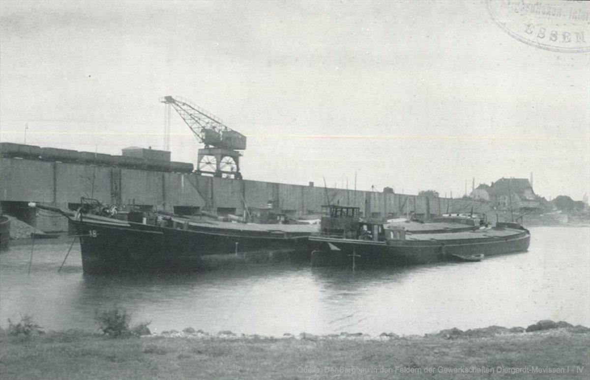
Mevissen Harbor


The port of Mevissen , more rarely the Rhine port of Diergardt-Mevissen or the port of Essenberg , was a port in Duisburg . It was located on the Rhine south of Essenberg in the Bergheim district of Rheinhausen , near the border with Alt-Homberg . It was used by the Wilhelmine-Mevissen and Diergardt mines on the left bank of the Rhine in the 20th century to ship the mined coal . Today only the former harbor basin bears witness to the port of Mevissen.
history
In Rheinhausen, the Mevissen and Diergardt mines began production between 1910 and 1913. A loading point at river kilometer 778.1 on the Rhine was set up as early as 1913 for the removal of the hard coal via the shipping route. This was south of the Essenberg ferry station, right next to a ship repair shop from the 18th century. It was fortified as a port until 1928. While shaft 2 of the Diergardt colliery was a few hundred meters west of the Rhine, the route from the two kilometers southwest of the Mevissen 1/2 and Diergardt 1 pits to the port was connected by a separate works railway line . Around a quarter of the non- coking production from the Mevissen colliery was shipped directly to France and the Netherlands via the port .
The port was expanded until 1948, probably during the National Socialist era . In the following years, during the economic miracle and the economic importance of hard coal, two loading cranes were in operation. Between 1967 and 1968, the Diergardt mine, which was taken over by the Mevissen colliery, ended. The mines have cooperated since they were founded and had been connected underground since 1957. When the Mevissen colliery ceased operations in 1973, the port was given up in the same year. Most recently, Mathias Stinnes AG and Ruhrkohle AG , or RAG for short, led him .
In the period that followed, in addition to the Mevissen 1/2 and Diergardt 1/2 pits, the entire port was also dismantled. Today only the former harbor basin can be seen. It is located on the Rheinhauser Rhine dike north of the landscape protection area " Rheinauengebiet Werthauser and Rheinhauser Wardt ". Today a footpath and bike path runs along the former railway line along the Diergardt Park and the sports facility of TuS Asterlagen .
Web links
- Entry by Kai-William Boldt about the port of Mevissen in Rheinhausen-Bergheim in the database " KuLaDig " of the Rhineland Regional Association
- Photograph of the port of Mevissen around 1935
Individual evidence
- ↑ a b Entry by Kai-William Boldt on the port of Mevissen in Rheinhausen-Bergheim in the database " KuLaDig " of the Rhineland Regional Association , accessed on April 14, 2020.
- ^ Norbert Rescher: Wilhelmine Mevissen colliery in Duisburg-Rheinhausen. ruhrzechenaus.de, accessed on April 14, 2020 .
- ↑ Armin Kähler: Z02 - Diergard Mevissen. zechenwandern.de, accessed on April 14, 2020 .
Coordinates: 51 ° 26 ′ 0.6 ″ N , 6 ° 42 ′ 40.3 ″ E