Hainholzgraben (Tarpenbek)
| Hainholzgraben | ||
|
Hainholzgraben after crossing under Garstedter Weg |
||
| Data | ||
| location | Hamburg-Niendorf | |
| River system | Elbe | |
| Drain over | Kollau → Tarpenbek → Alster → Elbe → North Sea | |
| source | At König-Heinrich-Weg 53 ° 37 ′ 35 ″ N , 9 ° 57 ′ 20 ″ E |
|
| muzzle | on the border to Hamburg-Fuhlsbüttel through a R-Siel the Tarpenbek coordinates: 53 ° 37 '18 " N , 9 ° 58' 0" E 53 ° 37 '18 " N , 9 ° 58' 0" E
|
|
| length | 1 km | |
| Big cities | Hamburg | |
| Navigable | No | |
|
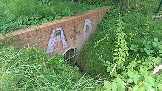
Mouth from the Hainholzgraben into an R-Siel |
||
The Hainholzgraben is an approx. 1000 meter long ditch in Hamburg-Niendorf . It flows into the Tarpenbek at the border to Hamburg-Fuhlsbüttel through a rainwater channel (R-Siel) .
course
It rises on König-Heinrich-Weg, runs along the Friederike-Büscher -Wanderweg, Düp-Ring and crosses under Garstedter Weg. It runs a few meters further south on the Friederike-Büscher-Wanderweg, crosses under the Niendorfer Höhe and the Fuhlsbütteler Weg, continues along a path and crosses under the Sugambrerweg and from the Nienkamp street runs underground parallel to the Hainholz street, crosses under the Steinhoffweg and the Engernweg and flows out then through an R-Siel into the Tarpenbek .
Individual evidence
- ↑ Complete list of rivers in the Elbe catchment area. Retrieved June 30, 2020 .
- ↑ Hainholzgraben on OpenStreetMap. Retrieved August 1, 2020 .
- ↑ Hainholzgraben map. Retrieved August 5, 2020 .

