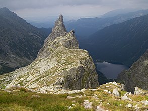
Hala za Mnichem
| Hala za Mnichem | ||
|---|---|---|
|
Hala za Mnichem |
||
| location | Lesser Poland Voivodeship , Poland | |
| Mountains | High Tatras , Tatras , Carpathians | |
| Geographical location | 49 ° 11 '45 " N , 20 ° 3' 5" E | |
|
|
||
| climate | High mountain climate | |
The Alm Hala za Mnichem (German: Alm behind the monk) is an alpine pasture in the Dolina Rybiego Potoku valley , specifically its hanging valley Dolina za Mnichem , in the Polish High Tatras in the Lesser Poland Voivodeship .
history
The alpine pasture was built in the 17th century as the highest alpine pasture in Poland and was in operation until the Tatra National Park was founded in 1954. The owners were the Murzański family from the village of Groń . The owners were expropriated in 1961.
tourism
Two hiking trails lead to the Alm:
▬ A red marked hiking trail leads through the valley from the Meerauge mountain laketo the Wrota Chałbinskiego mountain pass.
▬ The lower part of the valley is crossed by a yellow hiking trail,called Ceprostrada , from the Meerauge mountain laketo the Szpiglasowa Przełęcz mountain pass.
literature
- Zofia Radwańska-Paryska, Witold Henryk Paryski, Wielka encyklopedia tatrzańska , Poronin, Wyd. Górskie, 2004, ISBN 83-7104-009-1 .
- Tatry Wysokie słowackie i polskie. Mapa turystyczna 1: 25.000, Warszawa, 2005/06, Polkart ISBN 83-87873-26-8 .

