Dolina Rybiego Potoku
| Dolina Rybiego Potoku | ||
|---|---|---|
|
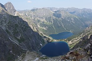
Dolina Rybiegi Potoku from Rysy summit |
||
| location | Lesser Poland Voivodeship , Poland | |
| Waters | Rybi Potok | |
| Mountains | High Tatras , Tatras , Carpathians | |
| Geographical location | 49 ° 12 '42 " N , 20 ° 4' 46" E | |
|
|
||
| height | 1400 to 2503 m npm | |
| length | 6 km | |
| climate | High mountain climate | |

The Fish Lake Valley ( Dolina Rybiego Potoku in Polish ), formed by glaciers in the Ice Age, is a side valley of the Bialka Valley in the Polish High Tatras in the Lesser Poland Voivodeship . It lies below the hanging valleys : Mönchkessel ( Nadspady ) and Mönchstal ( Dolina za Mnichem ).
geography
The valley is around 6 km long and surrounded by mountains over 2500 m high. a. the massif of Rysy ( Rysy ), Denésspitze ( Niżnie Rysy ), directing Koppe ( Spadowa Kopa ) Meeraughübel ( Bula pod Rysami ) Froschgrat ( Żabia Grań ): Large frog tip ( Żabi Szczyt Wyżni ), Frog monk ( Żabi Mnich ) Small frog tip ( Żabi Szczyt Nižní ), seven shells ( Siedem Granatów ) Mengsdorfer tip ( Mięguszowieckie Szczyty ), Ochs back ( wołowy Grzbiet ), Simon tower ( Żabi Koń ) rear monk ( Zadni Mnich ), monk , Cubryna , Liptauer ridge ( Szpiglasowa Grań ) Liptauer Grenzberg ( Szpiglasowy Wierch ) miedziane Grań , Kupferberg ( miedziane ), fire back ( Opalone ) and fire Koppe ( Opalony Wierch ). It has an area of approx. 7 km².
The valley drops from south to north from approx. 2500 meters in altitude to approx. 1400 meters in altitude. It is traversed by the mountain river Fischseebach ( Rybi Potok ), which flows into the Alpengrund-Weisswasser ( Białka ).
In the valley there are two large mountain lakes: Czarny Staw pod Rysami , Morskie Oko and three smaller lakes, the Little Sea Eye ( Małe Morskie Oko ), Frog Eye ( Żabie Oko ) and Little Frog Eye ( Małe Żabie Oko ) and the ponds in the Monks Valley ( Dolina za Mnichem ), u. a. the Staszic lake .
etymology
The Polish name means "Fischbach Valley". Sometimes you can also find the term "Fischseebachtal" in German.
Flora and fauna
The valley lies below and above the tree line and is overgrown by mountain pines in the lower area. The valley is a retreat for deer, bears, wolves, lynxes, chamois, marmots and eagles.
climate
There is a high mountain climate in the valley.
Alpine farming
Before the Tatra National Park was established in 1954, the valley had been used for alpine farming since the 17th century. After that, the owners of the alpine pastures were expropriated or forced to sell. Former alpine huts are still in the valley.
tourism
Numerous hiking trails lead through the valley from the surrounding mountain passes and peaks.
- ▬ A red marked path leads from Zakopane district Toporowa Cyrhla the Meerauhspitze ( Rysy ). The hiking trail partly follows the Oswald-Balzer-Weg .
- ▬ A red hiking trail leads around the Meerauge mountain lake.
- ▬ A blue marked trail leads from the mountain lake Sea eye over the mountain pass Świstówka Roztocká into Fünfseental even Ceprostrada called.
- ▬ A yellow-marked hiking trail leads from the Meerauge mountain lakeover the Szpiglasowa Przełęcz mountain passinto the Dolina Pięciu Stawów Polskich valley.
- ▬ A red hiking trail leads from the Meerauge mountain laketo the Chalubinski-Tor mountain pass.
- ▬ A green marked hiking trail leads from the mountain lake Czarny Staw pod Rysami to the mountain pass Wildererjoch ( Mięguszowiecka Przełęcz pod Chłopkiem ).
The Schronisko PTTK nad Morskim Okiem refuge is in the middle .
literature
- Zofia Radwańska-Paryska, Witold Henryk Paryski, Wielka encyklopedia tatrzańska , Poronin, Wyd. Górskie, 2004, ISBN 83-7104-009-1 .
- Tatry Wysokie słowackie i polskie. Mapa turystyczna 1: 25.000, Warszawa, 2005/06, Polkart ISBN 83-87873-26-8 .
map
panorama


