Wołowy Grzbiet
| Wołowy Grzbiet | ||
|---|---|---|
|
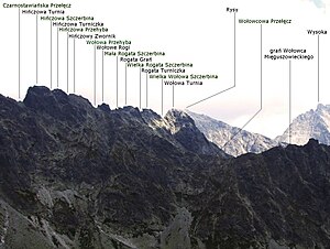
View from the Wyżna Koprowa Przełęcz pass |
||
| height | 2377 m npm | |
| location | Poland , Slovakia | |
| Mountains | High Tatras , Carpathian Mountains | |
| Coordinates | 49 ° 10 '48 " N , 20 ° 4' 18" E | |
|
|
||

The Wołowy Grzbiet (German ox back ) is a mountain range in the Polish High Tatras in the Lesser Poland Voivodeship and the Bukowina Tatrzańska municipality with a maximum altitude of 2377 m npm in Hińczowa Turnia . The Polish- Slovak border runs along the ridge, which is part of the main Tatra ridge .
Location and surroundings
Below the massif lie the Fischseetal ( Dolina Rybiego Potoku ) and Mengsdorf Valley ( Dolina Mięguszowiecka ) valleys . The massif borders over the Froschsee Scharte ( Żabia Przełęcz Wyżnia ) to the massif of the Meeraugspitze ( Rysy ) in the east and over the Eastern Mengsdorfer Scharte ( Czarnostawiańska Przełęcz ) to the massif of the Mengsdorfer Spitzen in the west. The massif forms the south face of the Karkessel of the mountain lake Czarny Staw pod Rysami , to which it falls steeply. On the south side of the massif, the slopes fall flat to the Mengsdorf Great Frog Lake ( Wielki Żabi Staw Mięguszowiecki ).
The course of the ridge of the massif from the mountain pass Östliche Mengsdorfer Scharte ( Czarnostawiańska Przełęcz ) in the west to the Froschsee Scharte ( Żabia Przełęcz Wyżnia ) in Soten runs as follows:
- The peak of the Hinzenseeturm ( Hińczowa Turnia ) 2377 m above sea level
- Hinzenseekerbe mountain pass ( Hińczowa Szczerbina ) ~ 2355 m above sea level
- The peak of the Hinzensee tower ( Hińczowa Turniczka ) ~ 2360 m above sea level
- Mountain Pass High Hinzenseedurchgang ( Hińczowa Przehyba ) ~ 2345 m above sea level
- Hinzenseekoppe peak ( Hińczowy Zwornik ) ~ 2360 m above sea level
- Lower Hinzensee Pass ( Wołowa Przehyba ) mountain pass ~ 2350 m above sea level
- Summit Ochs croissants ( wołowe Rogi ):
- Western ox squirrel ( Zachodni Wołowy Róg ) ~ 2370 m above sea level
- Western ox-back notch ( Mała Wołowa Szczerbina ) ~ 2355 m above sea level
- Eastern ox squirrel ( Wschodni Wołowy Róg ) ~ 2370 m above sea level
- Ox passage ( Wołowy Przechód ) ~ 2350 m above sea level
- Little ox squirrel ( Mały Wołowy Róg ) ~ 2360 m above sea level
- Small Ochsenhornscharte mountain pass ( Mała Rogata Szczerbina ) ~ 2355 m above sea level
- Great Ochsenhornscharte mountain pass ( Wielka Rogata Szczerbina ) ~ 2355 m above sea level
- The peak of the ox- horn tower ( Rogata Turniczka ) ~ 2368 m above sea level
- Great Ochsenrückenscharte ( Wielka Wołowa Szczerbina ) mountain pass ~ 2355 m above sea level
- Summit Ochsenrückenturm ( Wołowa Turnia ) 2373 m above sea level
- Eastern Ochsenrückenscharte mountain pass ( Żabia Przełęcz Mięguszowiecka ) ~ 2315 m above sea level
- Summit of the Froschsee Tower ( Żabia Turnia Mięguszowiecka ) 2335 m above sea level
etymology
The Polish name wołowy Grzbiet also means ox back . The name comes from the fact that the shape of the massif reminded the Góralen of an ox back with horns.
Flora and fauna
The ox back is a refuge for birds of prey, etc. a. Golden eagle, but not a strictly protected nature reserve.
tourism
The peaks can be climbed by climbers with the approval of the respective national park administration . The Schronisko PTTK nad Morskim Okiem refuge on the Meerauge mountain lake is particularly suitable as a starting point for climbing tours .
Web links
supporting documents
- Zofia Radwańska-Paryska, Witold Henryk Paryski, Wielka encyklopedia tatrzańska, Poronin, Wyd. Górskie, 2004, ISBN 83-7104-009-1 .
- Tatry Wysokie słowackie i polskie. Mapa turystyczna 1: 25.000, Warszawa, 2005/06, Polkart, ISBN 83-87873-26-8 .


