
Białka (Dunajec)
|
Białka Biela voda |
||
 Białka at Białka Tatrzańska . |
||
| Data | ||
| location | Slovakia , Poland | |
| River system | Vistula | |
| Drain over | Dunajec → Vistula → Baltic Sea | |
| source | northwest of the Gerlsdorfer Spitze in the High Tatras 49 ° 10 ′ 37 ″ N , 20 ° 7 ′ 1 ″ E |
|
| Source height | 1575 m nm | |
| muzzle | in the Dunajec coordinates pent up here to Jezioro Czorsztyńskie : 49 ° 27 '35 " N , 20 ° 13' 7" E 49 ° 27 '35 " N , 20 ° 13' 7" E |
|
| Mouth height | 529 m npm | |
| Height difference | 1046 m | |
| Bottom slope | 26 ‰ | |
| length | 41 km | |
| Catchment area | 230 km² | |
| Left tributaries | Rybi Potok , Roztoka , Waksmundzki Potok , Zawierszański Potok , Brzegowski Potok , Pogórzański Potok , Odewsiański Potok , Kaniowski Potok , Czerwonka | |
| Right tributaries | Biała Woda Białczańska , Jaworowy Potok , Suchy Potok , Jurgowczyk , Szynkowski Potok , Trybska Rzeka , Kiźlinkowy Potok | |
| Flowing lakes | Zelené Kačacie pleso | |
| Reservoirs flowed through | Jezioro Czorsztyńskie | |
| Communities | Bukowina Tatrzańska , Nowy Targ | |
The Białka is a 41 km long right tributary of the Dunajec in the Lesser Poland Voivodeship in Poland and Slovakia . It has the character of a high mountain river.
geography
The river has its source in Slovakia to the northwest of Gerlachovský štít (Gerlsdorf Peak), the highest mountain in the High Tatras , in a cirque of the Kačacia dolina (duck valley). It then flows through the small Karsee Zelené Kačacie pleso (Duck Valley Green Lake) located at an altitude of 1575 m , flows through the Bielovodská dolina as Biela voda to the north and forms from the intake of the Rybi Potok brook to the border with Poland. On the Polish side it is called Białka. In the High Tatras it still absorbs the waters of the Roztoka and Waksmundzki Potok mountain streams , which flow in from the left. Below the Alm Łysa Polana it is crossed by a connecting road from Poland to Slovakia (on the Polish side Voivodeship road 960, on the Slovak side Cesta I. triedy 66 ). In Łysa Polana he leaves the Tatra National Park and the High Tatras. It forms the Polish-Slovakian border up to the confluence of the Javorinka flowing in from the right and then leads to Poland, where it forms the border between the historical landscapes of Podhale and Spiš . In its lower course it turns to the northeast and flows through the villages of Bukowina Tatrzańska , Brzegi , Jurgów , Białka Tatrzańska , Czarna Góra , Trybsz , Nowa Biała and Krempachy as well as the regions of Zips-Gubałówka Highlands and Orawa-Nowy Targ Basin . At Krempachy he breaks through the nature reserve Białka breakthrough . It flows between Frydman and Dębno in the Jezioro Czorsztyńskie reservoir in the Dunajec dammed here . The catchment area is given as 410.6 km².
Surname
The name "Białka" ("the white one") comes from the white stones in the river bed.
Flora and fauna
The water of the Białka is clean, rainbow trout, trout, grayling, bullhead and minnow live in the river. The river is surrounded by spruce forests.
tourism
The river is used for tourism. White water kayaking and rafting are popular outside of the national park and reserve, as is fishing and angling.
River course

source
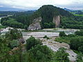
Breakthrough at Krempachy


literature
- Vysoke Tatry, Turistická Mapa 1: 50,000, VKÚ Harmanec, sheet 113, 2002, ISBN 80-8042-312-1
Web links
Individual evidence
- ↑ Klimaszewski, Mieczysław, Geomorfologia Polski, Warszawa, 2003, ISBN 83-01-13951-X
- ↑ Dąbrowski, P., Ochrona Przyrody w Pienińskim Pasie Skałkowym, Oddział Akademicki PTTK, Kraków, 1984, ISBN 00-01-09630-3