
Waksmundzki Potok
| Waksmundzki | ||
 Waksmundzki Potok |
||
| Data | ||
| location | Poland | |
| River system | Vistula | |
| Drain over | Białka → Dunajec → Vistula → Baltic Sea | |
| source | north of the pass between Wielki Wołoszyn (2155 m) & Mały Wołoszyn (2145 m) 49 ° 13 ′ 43 ″ N , 20 ° 2 ′ 59 ″ E |
|
| Source height | 1950 m npm | |
| muzzle | in the Białka coordinates: 49 ° 15 ′ 3 ″ N , 20 ° 6 ′ 4 ″ E 49 ° 15 ′ 3 ″ N , 20 ° 6 ′ 4 ″ E |
|
| Mouth height | 987 m npm | |
| Height difference | 963 m | |
| Bottom slope | 16% | |
| length | 6 km | |
| Communities | Bukowina Tatrzańska | |
The Waksmundzki Potok is an approximately seven-kilometer-long left tributary of the Białka in the Lesser Poland Voivodeship in Poland . It has the character of a high mountain river.
geography
The river has its source north of the pass between Wielki Wołoszyn (2155 m) and Mały Wołoszyn (2145 m) in the Dolina Waksmundzka valley in the High Tatras , which it flows through its entire length. Shortly before it flows into the Białka, it flows into the Dolina Białki valley . The whole course of the river is in the Tatra National Park .
Surname
Waksmundzki Potok can be derived from the place Waksmund , who owned the valley.
Flora and fauna
The water of the Waksmundzki Potok is clean, rainbow trout, trout, grayling, bullhead and minnow live in the river. The river is surrounded by spruce forests.
tourism
The river and the Dolina Waksmundzka valley are a strict nature reserve that is not accessible to tourists. A marked hiking trail leads across its lower reaches.
River course

Bridge over the river
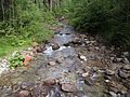
Lower course of the river

Lower course of the river


literature
- Zofia Radwańska-Paryska, Witold Henryk Paryski, Wielka encyklopedia tatrzańska, Poronin, Wyd. Górskie, 2004, ISBN 83-7104-009-1 .
- Tatry Wysokie słowackie i polskie. Mapa turystyczna 1: 25.000, Warszawa, 2005/06, Polkart ISBN 83-87873-26-8 .