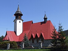
Czarna Góra (Bukowina Tatrzańska)
| Czarna Góra | ||
|---|---|---|
 Help on coat of arms |
|
|
| Basic data | ||
| State : | Poland | |
| Voivodeship : | Lesser Poland | |
| Powiat : | Zakopane | |
| Gmina : | Bukowina Tatrzańska | |
| Geographic location : | 49 ° 23 ' N , 20 ° 8' E | |
| Residents : | 1661 (2012) | |
| Postal code : | 34-532 | |
| Telephone code : | (+48) 18 | |
| License plate : | KNT | |
Czarna Góra ( Slovak Čierna Hora , Hungarian Csarnagura , from 1899 Feketebérc ; German Schwarzberg ) is a village with a school administration of the municipality of Bukowina Tatrzańska in the powiat Tatrzański of the Lesser Poland Voivodeship in Poland .
geography
The place is located on the right bank of the Białka River .
history
Czarna Góra is one of the fourteen villages in the Polish Spiš .
The place arose from cleared islands and was settled by five shepherd families in the late 16th century. In the early 17th century it was founded by the Horváth-Palocsay family under Wallachian law . In the 19th century, Slovak became the language of the church and schools, but the local Gorals spoke Goral , a dialect of Polish descent that was always considered Slovak in the Hungarian censuses, unlike the Goral villages of the Arwa . A policy of Magyarization was later pursued.
In 1918, after the end of the First World War and the collapse of the Austro-Hungarian monarchy, the village became part of the newly formed Czechoslovakia. As a result of the Czechoslovak-Polish border conflicts in the Spiš area, the place was assigned to the Second Polish Republic in 1920. Between 1920 and 1925 he belonged to the powiat Spisko-Orawski , from July 1, 1925 to the powiat Nowotarski. In 1921 the municipality of Czarnogóra had 136 houses with 681 inhabitants, all of them Roman Catholic Poles.
From 1939 to 1945 the village became part of the Slovak State .
From 1975 to 1998 Czarna Góra was part of the Nowy Sącz Voivodeship .
tourism
Winter sports
The Grapa-Litwinka and Koziniec ski areas , which are part of the TatrySki ski pass association , are located in the municipality .
Web links
Individual evidence
- ↑ Bogumił Złahoda: Dzieje Góry Czarnej do roku 1939 . Kraków 1995 (Polish).
- ↑ Główny Urząd Statystyczny: Skorowidz miejscowości Rzeczypospolitej Polskiej. Województwo krakowskie i Śląsk Cieszyński . Warszawa 1925 (Polish, online ).
- ↑ Dz.U. 1975 no 17 poz. 92 (Polish) (PDF file; 783 kB)


