
Roztoka (Białka)
| Roztoka | ||
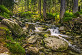
 Roztoka at the outflow through the mountain lake Wielki Staw Polski |
||
| Data | ||
| location | Poland | |
| River system | Vistula | |
| Drain over | Białka → Dunajec → Vistula → Baltic Sea | |
| source | Mountain lake Wielki Staw Polski 49 ° 12 ′ 44 ″ N , 20 ° 2 ′ 31 ″ E |
|
| Source height | 1665 m npm | |
| muzzle | in the Białka coordinates: 49 ° 14 '10 " N , 20 ° 5' 53" E 49 ° 14 '10 " N , 20 ° 5' 53" E |
|
| Mouth height | 1020 m npm | |
| Height difference | 645 m | |
| Bottom slope | 92 ‰ | |
| length | 7 km | |
| Left tributaries | Buczynowy Potok | |
| Flowing lakes | Wielki Staw Polski | |
| Communities | Bukowina Tatrzańska | |
The Roztoka is an approximately seven kilometers long left tributary of the Białka in the Lesser Poland Voivodeship in Poland . It has the character of a high mountain river.
geography
The river has its source in the mountain lake Wielki Staw Polski in the valley Dolina Pięciu Stawów Polskich in the High Tatras . Several smaller mountain streams from the higher mountain lakes of the valley flow into the lake. It then falls in the Siklawa waterfall into the Dolina Roztoki valley , which it flows through its entire length. Shortly before it flows into the Białka, it falls into the Wodogrzmoty Mickiewicza waterfalls in the Dolina Białki valley . The whole course of the river is in the Tatra National Park .
Surname
The name Roztoka can be translated as "the flowing stream".
Flora and fauna
The water of the Roztoka is clean, rainbow trout, trout, grayling, bullhead and minnow live in the river. The river is surrounded by spruce forests.
tourism
The river is accessible via a green hiking trail.
River course

Outflow into the Dolina Roztoki valley
Lower river course

Lower river course


literature
- Zofia Radwańska-Paryska, Witold Henryk Paryski: Wielka encyklopedia tatrzańska. Wydawnictwo Górskie, Poronin 2004, ISBN 83-7104-009-1 .
- Tatry Wysokie słowackie i polskie. Mapa turystyczna 1: 25000, Polkart, Warszawa 2005/06, ISBN 83-87873-26-8 .