Hançerli
Coordinates: 36 ° 30 ′ 32.7 ″ N , 33 ° 59 ′ 51.6 ″ E
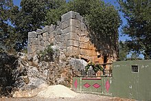
Hançerli , also Hançerli Kale or Hançer Kalesi , is the Turkish name of an ancient tower in the rough Cilicia .
location
The tower stands in the mountainous hinterland of Silifke, in the center of the village Ovacık in the district of Silifke in the Turkish province of Mersin , right next to the local mosque. The place is on the road that leads from Narlıkuyu inland past the Koryk Grottoes and through Hasanaliler to Uzuncaburç , the ancient Olba . In Hellenistic and Roman times it belonged to the domain of the priestly dynasty of Olba and Diokaisareia.
description
The tower has basic dimensions of about 7.60 × 6.00 meters, the height that has been preserved is 5.86 meters. It is made of polygonal masonry . It is the only one among the numerous towers of the Rough Cilicia where the polygonal blocks are smooth on the outside. In the interior, the stones are embossed as usual . The interior has a floor plan of 5.58 × 4.12 meters. The 1.50 meter high and 1.10 meter wide door is 3.60 meters from the left on the south wall. Your threshold is one meter above the level of the surroundings. The building is almost entirely built on the adjacent rock. The door threshold is also made from this, the rock steps leading up to it have not been preserved. A device for a locking bar can be seen inside.
The north and east sides of the tower are windowless, the east wall is only broken through by a water drainage channel with a spout. From its location it can be concluded that the ground floor was five meters high. The south side has, a row of stones above the lintel, a slot window 76 centimeters high and an outer width of 10 centimeters. A similar window, 58 × 16 centimeters, is at the same height in the west wall. On the lintel there are four Olbic characters in relief, a short sword, an oval shield, a club and a dioskur cap ( pileus ). They prove that the building belongs to the Olbian territory. According to the archaeologists Friedrich Hild and Hansgerd Hellenkemper , the tower was still used as a residential building in the early Byzantine period. Nothing has been preserved from the upper floors. The Turkish archaeologist Serra Durugönül , who researched the towers in Rough Cilicia in the late 1990s, reports that, according to statements from the villagers, the stones were used in the 1930s for the construction of the mosque and the school, both of which are in the immediate vicinity lie. According to the masonry technique, she dates the tower to the 2nd century BC. Chr.
The current designations Hançerli Kale or Hançer Kalesi ( Turkish for castle with dagger ) are misleading because the building is not a castle, but a watchtower. The word Hançer (dagger) refers to the short sword mentioned on the lintel.
literature
- Serra Durugönül: towers and settlements in the Rough Cilicia. Asia Minor Studies Volume 28. Rudolf Habelt, Bonn 1998 ISBN 3-7749-2840-1 pp. 13-19, 92, 121.
Web links
Individual evidence
- ↑ Friedrich Hild, Hansgerd Hellenkemper: Kilikien and Isaurien. (= Tabula Imperii Byzantini Volume 5). Publishing house of the Austrian Academy of Sciences, Vienna 1990, ISBN 3-7001-1811-2 , p. 270


