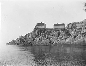
Hattholmen fyr
| Hattholmen fyr | ||
|---|---|---|
| Hattholmen between 1890 and 1900 | ||
| Place: | Mannefjorden | |
| Location: | Agder , Norway | |
| Geographical location: | 58 ° 0 '12 " N , 7 ° 26' 54" E | |
| Fire carrier height : | 7.2 m | |
| Fire height : | 19 m | |
|
|
||
| Identifier : | Fl (2) WRG 10s | |
| Scope knows: | 5.3 nm (9.8 km ) | |
| Scope green: | 3.4 nm (6.3 km ) | |
| Scope red: | 3.6 nm (6.7 km ) | |
| Optics: | Lens apparatus | |
| Operating mode: | automated since 1973 | |
| Function: | Fairway lights | |
| Operating time: | since 1867 | |
Hattholmen fyr (also Hatholmen ) is a lighthouse in Agder ( Norway ) and is located on the east side of the island of Indre Hatholmen in Mannefjorden in front of the port of Mandal (municipality of Lindesnes ).
history
The lighthouse was built in 1867 at the same time as Ryvingen fyr and has both a functional and a visual connection to it. The lighthouse is built as a 1½ storey wooden house with a light room on the roof. The lens apparatus dates from 1931. In 1985 the tower was converted to solar cell operation.
The tower has been automated and unmanned since 1973. On September 12, 1997, the entire complex was placed under monument protection.
Web links
- HATTHOLMEN FYRSTASJON. NORSK FYRHISTORISK FORENING, accessed December 5, 2018 (Norwegian).
Individual evidence
- ↑ Leif Arne Larsen: Fyrliste for Sørøst. (PDF) Kystverket, May 23, 2014, p. 78 , accessed on December 5, 2018 (Norwegian, Oppdatert: September 18, 2018 ).
- ↑ Hatholmen fyrstasjon. 86962. In: kulturminnesok.no. Retrieved December 5, 2018 (Norwegian).

