Havelschanze
| Havelschanze | |
|---|---|
| Street in Berlin | |
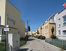
| Town houses on the Havelschanze | |
| Basic data | |
| place | Berlin |
| District | Hook field |
| Created | 1958 |
| Connecting roads | Askanierring (west) |
| Cross streets | At the boathouse, to the old lido |
| use | |
| User groups | Pedestrian traffic , bicycle traffic , car traffic |
| Technical specifications | |
| Street length | 480 meters |
Havelschanze is the name of a street in the Berlin district of Hakenfelde in the Spandau district .
location
The Havelschanze leads eastwards from Neuendorferstrasse / Streitstrasse as a cul-de-sac to Spandauer See, where it ends as a dead end with a turning hammer on the Havel . Only the two pedestrian streets Am Bootshaus and Zum Alten Strandbad lead further to the immediate shore area.
Surname
The Havelschanze has only had its name since January 29, 1958. It is derived from one of the nine ski jumps which, as part of the Spandau Fortress, surrounded the city and the Spandau citadel in the north . The Havelschanze was the ninth and easternmost bastion of the facility.
At the eastern end of the street you can still see the remnants of a street that reaches up to Schäferstraße to the south and was formerly called Schanzenstraße .
The Havel as the namesake for street names in Spandau ("Havelstadt", "Capital of the Havellandes") is documented many times: Havelchaussee , Havelmatensteig, Havelstraße, as well as Am Havelgarten, Am Havelufer, An der Havelspitze or meanwhile historical names like An der Havel and Havelberg .
history

Between 1909 and 1958 the Havelschanze was called Askanierring . The street of the same name continues today as an extension from Neuendorferstraße / Streitstraße to Straße Flankenschanze. After 1958, the section of the Askanierring, known today as the Havelschanze, was separated by a barracks area. Since 2007 there has been a direct connection to both roads again.
The Havelschanze runs on the south side of the Spandauer Nordhafen , which was built in 1912, but has long since lost its function. Until 2008, the nameplate “Bootswerft Nordhafen” and numerous ship moorings announced the original task, but the demolition and redesign were inevitable: the large-scale complex of the constantly expanding Haus Havelblick senior center with more than 700 residential, home and care places has shaped the image of the street since 2001.
In its continuation, a small terraced housing estate was built in 2007 and 2008, which directs its gaze over the northern harbor to the Maselakepark, which was laid out in 2006 . Between the terraced houses and the Havelblick house , comfortable townhouses belonging to the senior citizen center ( assisted living , living group for people with dementia ) were completed.
On the other side of the road from the Havelschanze, one has been looking for over a hundred years into the tranquil gardens with cozy-looking arbors of the Kleckersdorf 1898 colony , which directly adjoins the grounds of the more than one hundred year old Protestant children's home Sonnenhof Kaiser Wilhelm II (home for children and young people with fetal alcohol syndrome ).
The Havelschanze is now part of the Havel cycle path and the Königin-Luisen-Route .
Web links
- Havelschanze. In: Street name lexicon of the Luisenstädtischer Bildungsverein (near Kaupert )
- Askanierring with Luise
Coordinates: 52 ° 33 ′ 13.7 " N , 13 ° 12 ′ 43.3" E

