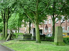
Holy Spirit Cemetery

The Heilig-Geist-Kirchhof was the burial place of the main parish of St. Trinitatis zu Altona from 1741 to 1878 . The facility was located between Königstrasse and Kleine Mühlenstrasse, today's Struenseestrasse. In connection with the construction of the City-S-Bahn Hamburg and the Königstraße station, the cemetery was de-dedicated in the 1970s and converted into a public green area, which was named Schleepark after the Altona reform pedagogue Ernst Schlee . Some grave structures and tombstones of formerly important Altona families have been preserved in the park. An associated building complex was historically significant: the Reventlow monastery and the Holy Spirit Chapel, which was destroyed by bombs in the Second World War .
The Reventlow pen
After Altona was burned down by the Swedes in the Great Northern War in 1713, Count Reventlow had the monastery built from 1713 to 1718. The facility was intended to provide shelter for the poorest of the Altona residents after the devastating fire. The center of the monastery was the Chapel of the Holy Spirit, which was opposite the poor houses. In 1880 the residential buildings had to be demolished because they were in disrepair. The Reventlow-Stift was rebuilt with the help of the Altonaic Support Institute on Adolphstrasse (today Bernstorffstrasse 149) and received a Holy Spirit Church there again. After destruction in the Second World War and with new buildings in the 1980s, the monastery still exists there today as a municipal facility for assisted living .
The Holy Spirit Chapel
The baroque chapel was built between 1716 and 1718 by Altona's city architect Claus Stallknecht . It was a cuboid , two-story building with a high hipped roof , which was crowned by a slender roof turret. The front was five axes wide, the center of the building was framed by two pilasters and emphasized with a small gable. After the monastery was relocated in 1880, the small chapel was used as an art and trade hall. In the nights of bombing in 1943 it burned down to the surrounding walls, after the war the building was not restored and the remains were demolished. Today there is access to the Königstraße S-Bahn station.
Individual evidence
- ↑ Michael Borkowski: Archived copy ( Memento of the original from April 2, 2015 in the Internet Archive ) Info: The archive link was inserted automatically and has not yet been checked. Please check the original and archive link according to the instructions and then remove this notice.
- ^ Report on the municipality administration of the city of Altona in the years 1863 to 1900. P. 120 books.google
- ^ Rolf Lange: Architectural Guide Hamburg . P. 95 f. books.google ; Archived copy ( memento of the original from March 4, 2016 in the Internet Archive ) Info: The archive link was inserted automatically and has not yet been checked. Please check the original and archive link according to the instructions and then remove this notice.
- ^ Landesbetrieb Geoinformation und Vermessung: Hamburg in aerial photographs and pictures 1933 to 1963 , p. 49 books.google
literature
- Fritz Lachmund: Alt-Altona. A picture chronicle in contemporary photos. Hamburg, Friba-Verlag 1964.
- Fritz Lachmund (ed.): Altona & Ottensen. Pictures from days gone by. Verlag Hans Christians, Hamburg 1974, ISBN 3-7672-0267-0 , p. 57
Web links
Coordinates: 53 ° 32 ′ 51 ″ N , 9 ° 56 ′ 36 ″ E
